Fairfax County General :
Fairfax Underground

Welcome to Fairfax Underground, a project site designed to improve communication among residents of Fairfax County, VA. Feel free to post anything Northern Virginia residents would find interesting.
https://wtop.com/weather-news/2018/09/md-and-va-officials-warn-of-massive-flooding-as-florence-eyes-east-coast/
https://www.weather.gov/lwx/
https://www.nhc.noaa.gov/
Gov. Larry Hogan declared a state of emergency Monday afternoon in anticipation of Hurricane Florence’s potential effects on Maryland.
“We are preparing for the potential of historic, catastrophic and life-threatening flooding in Maryland,” Hogan said during a news conference.
Of particular concern, Hogan said, are low-lying and coastal areas, many of which are already water-logged from a very wet summer. Shelters are standing by to receive any displaced residents, and utility companies are prepared for severe outages.
“Things are fast-moving and constantly changing,” Hogan said.
Still over the Atlantic, Florence is poised to strike the East Coast on Thursday night. Strong winds, storm surge, and life-threatening flooding are in store into early next week.
Mandatory evacuations have been ordered for the Outer Banks. A mandatory evacuation started at noon for Hatteras and Ocracoke islands in North Carolina. Other parts of the Outer Banks are ordered to evacuate starting at 7 a.m. Tuesday.
Monday afternoon, South Carolina’s governor ordered an evacuation of the state’s entire coastline starting at noon Tuesday.
Here’s the latest on Florence, what the D.C. area can expect, and how officials are responding to the storm.
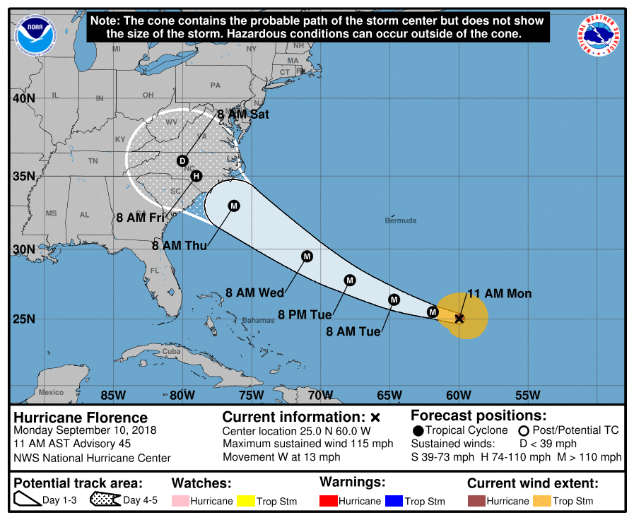
At noon, Category 4 Hurricane Florence packed winds of 130 miles per hour over the open Atlantic. The National Hurricane Center (NHC) said the storm had rapidly strengthened into a major hurricane, and would continue to grow both in size and strength through Monday.
“As Florence approaches the southeastern United States, there will likely be fluctuations in intensity from eyewall cycles, but even if this occurs, the hurricane’s wind field is expected to grow with time, increasing the storm surge and inland wind threats,” the NHC said.
The projected path is honing in on a Carolinas landfall around Thursday night — though forecasters cautioned it’s still too far out to know for certain exactly where Florence could come ashore. The outlook calls for Florence to be an extremely powerful, high-end Category 4 storm with winds up to 150 miles per hour as it nears the coast.
The NHC said damaging hurricane-force winds are likely along portions of the Carolina shoreline, and a hurricane watch will likely be needed for those areas by Tuesday morning. It also warned of damaging winds spreading inland through the Carolinas into Virginia.
What’s in store for the DC area
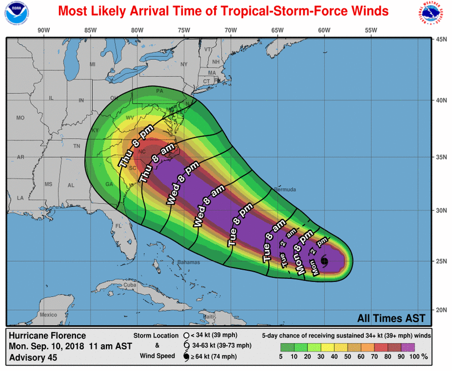
According to the official forecast, there’s about a 30 percent chance that the D.C. area could see at least tropical storm force winds of over 40 miles per hour from Florence. If that does pan out, those winds would most likely arrive late Thursday night.
D.C. is unlikely to experience hurricane-force winds, since the storm will lose its punch after it makes landfall hundreds of miles to the south. For the Virginia, Maryland, and D.C. regions, it’s widespread flooding that’s fast becoming a concern.
Although it’s still too far out to know for certain what the impacts on the area will be, computer models are flirting with the idea that Florence could slow down drastically over land.
That has the potential to bring persistent tropical downpours to much of Virginia up into D.C. from Friday into early next week. The ground is already saturated from days of rain by a separate weather system.
NOAA’s Monday GFS model highlighted the potential for up to a foot of rainfall in southeast Virginia and southern Maryland.
That said, the latest run of the European model brings Florence ashore farther south, and moves it more inland — a path that would bring less rain to D.C.
A European-model path, however, would take a big toll on the Shenandoah Valley, and ultimately impact the D.C. area as a bloated Shenandoah River empties into the Potomac.
During a Facebook Live Monday afternoon, Storm Team4 Meteorologist Doug Kammerer explained that such a heavy volume of water — combined with eastern winds hampering their flow into the Chesapeake, could cause “major problems.”
“This is about as serious of a storm as we get,” Kammerer said.
Edited 1 time(s). Last edit at 09/10/2018 04:42PM by Fox News.
All of the same "urgency hype" was heard when Terry McAuliffe claimed EMERGENCY and it didn't even get in Virginia. It also didn't do much of any damage in Carolina's. They claimed it would be category 4. When it hit land it was a weak 3 if that (3 including "puffery" for insurance and government rip-off reasons).
Welcome to Fairfax Underground, a project site designed to improve communication among residents of Fairfax County, VA. Feel free to post anything Northern Virginia residents would find interesting.
Hurricane Florence Fairfax County VA
Posted by:
Fox News
()
Date: September 10, 2018 04:39PM
https://wtop.com/weather-news/2018/09/md-and-va-officials-warn-of-massive-flooding-as-florence-eyes-east-coast/
https://www.weather.gov/lwx/
https://www.nhc.noaa.gov/
Gov. Larry Hogan declared a state of emergency Monday afternoon in anticipation of Hurricane Florence’s potential effects on Maryland.
“We are preparing for the potential of historic, catastrophic and life-threatening flooding in Maryland,” Hogan said during a news conference.
Of particular concern, Hogan said, are low-lying and coastal areas, many of which are already water-logged from a very wet summer. Shelters are standing by to receive any displaced residents, and utility companies are prepared for severe outages.
“Things are fast-moving and constantly changing,” Hogan said.
Still over the Atlantic, Florence is poised to strike the East Coast on Thursday night. Strong winds, storm surge, and life-threatening flooding are in store into early next week.
Mandatory evacuations have been ordered for the Outer Banks. A mandatory evacuation started at noon for Hatteras and Ocracoke islands in North Carolina. Other parts of the Outer Banks are ordered to evacuate starting at 7 a.m. Tuesday.
Monday afternoon, South Carolina’s governor ordered an evacuation of the state’s entire coastline starting at noon Tuesday.
Here’s the latest on Florence, what the D.C. area can expect, and how officials are responding to the storm.
At noon, Category 4 Hurricane Florence packed winds of 130 miles per hour over the open Atlantic. The National Hurricane Center (NHC) said the storm had rapidly strengthened into a major hurricane, and would continue to grow both in size and strength through Monday.
“As Florence approaches the southeastern United States, there will likely be fluctuations in intensity from eyewall cycles, but even if this occurs, the hurricane’s wind field is expected to grow with time, increasing the storm surge and inland wind threats,” the NHC said.
The projected path is honing in on a Carolinas landfall around Thursday night — though forecasters cautioned it’s still too far out to know for certain exactly where Florence could come ashore. The outlook calls for Florence to be an extremely powerful, high-end Category 4 storm with winds up to 150 miles per hour as it nears the coast.
The NHC said damaging hurricane-force winds are likely along portions of the Carolina shoreline, and a hurricane watch will likely be needed for those areas by Tuesday morning. It also warned of damaging winds spreading inland through the Carolinas into Virginia.
What’s in store for the DC area
According to the official forecast, there’s about a 30 percent chance that the D.C. area could see at least tropical storm force winds of over 40 miles per hour from Florence. If that does pan out, those winds would most likely arrive late Thursday night.
D.C. is unlikely to experience hurricane-force winds, since the storm will lose its punch after it makes landfall hundreds of miles to the south. For the Virginia, Maryland, and D.C. regions, it’s widespread flooding that’s fast becoming a concern.
Although it’s still too far out to know for certain what the impacts on the area will be, computer models are flirting with the idea that Florence could slow down drastically over land.
That has the potential to bring persistent tropical downpours to much of Virginia up into D.C. from Friday into early next week. The ground is already saturated from days of rain by a separate weather system.
NOAA’s Monday GFS model highlighted the potential for up to a foot of rainfall in southeast Virginia and southern Maryland.
That said, the latest run of the European model brings Florence ashore farther south, and moves it more inland — a path that would bring less rain to D.C.
A European-model path, however, would take a big toll on the Shenandoah Valley, and ultimately impact the D.C. area as a bloated Shenandoah River empties into the Potomac.
During a Facebook Live Monday afternoon, Storm Team4 Meteorologist Doug Kammerer explained that such a heavy volume of water — combined with eastern winds hampering their flow into the Chesapeake, could cause “major problems.”
“This is about as serious of a storm as we get,” Kammerer said.
Edited 1 time(s). Last edit at 09/10/2018 04:42PM by Fox News.
Re: Hurricane Florence Fairfax County VA
Posted by:
Skint Headed Board Member
()
Date: September 10, 2018 04:43PM
I'm calling it now. About to Twitter it.
No school next Monday and maybe beyond.
Biblical rain cometh.
No school next Monday and maybe beyond.
Biblical rain cometh.
Re: Hurricane Florence Fairfax County VA
Posted by:
Survival Kit
()
Date: September 10, 2018 08:42PM
Be prepared for any situation
Attachments:
.jpg")
Attachments:
Re: Hurricane Florence Fairfax County VA
Posted by:
wefddsf
()
Date: September 10, 2018 09:04PM
All of the same "urgency hype" was heard when Terry McAuliffe claimed EMERGENCY and it didn't even get in Virginia. It also didn't do much of any damage in Carolina's. They claimed it would be category 4. When it hit land it was a weak 3 if that (3 including "puffery" for insurance and government rip-off reasons).
ONCE YOU LIE YOUR FUCKING DONE. NO REASON FOR ANYONE TO TRUST YOU AFTER THAT
ONCE YOU LIE YOUR FUCKING DONE. NO REASON FOR ANYONE TO TRUST YOU AFTER THAT
Re: Hurricane Florence Fairfax County VA
Posted by:
fgds
()
Date: September 10, 2018 09:05PM
All of the same "urgency hype" was heard when Terry McAuliffe claimed EMERGENCY and it didn't even get in Virginia. It also didn't do much of any damage in Carolina's. They claimed it would be category 4. When it hit land it was a weak 3 if that (3 including "puffery" for insurance and government rip-off reasons).
ONCE YOU LIE YOUR FUCKING DONE. NO REASON FOR ANYONE TO TRUST YOU AFTER THAT
Re: Hurricane Florence Fairfax County VA
Posted by:
Doug Tracht
()
Date: September 16, 2018 02:19AM
I thought Terry McAuliffe died in the Space Shuttle Challenger Disaster. If I'm mistaken, I guess I'm the glum cunt.