Fairfax County General :
Fairfax Underground

Welcome to Fairfax Underground, a project site designed to improve communication among residents of Fairfax County, VA. Feel free to post anything Northern Virginia residents would find interesting.
9:50 am, October 5, 2016
62°
Well, a lot has changed overnight. The track of Hurricane Matthew has shifted once again, as expected, and the scenario is what we were hoping for around the WTOP listening area. As for areas along the southeastern portion of the United States (including Florida, South Carolina and Georgia), the projection doesn’t look good.
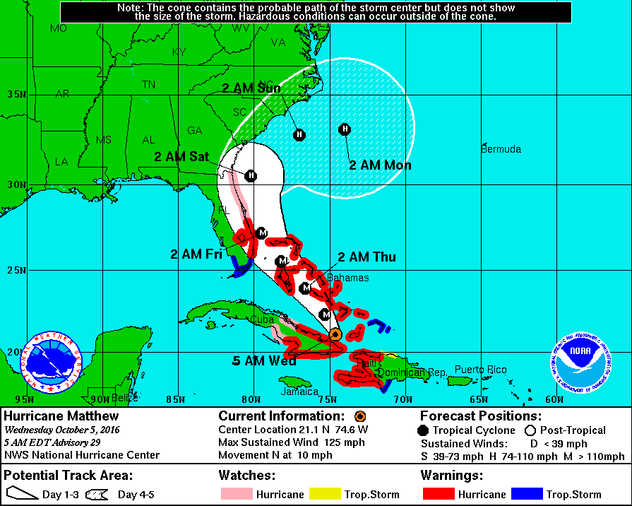
The track of Hurricane Matthew at 5 a.m. Oct. 5, 2016. (NBC Washington)
The track of Hurricane Matthew at 5 a.m. Oct. 5, 2016. (NBC Washington)
As of 5 a.m., Hurricane Matthew is a Category 2 hurricane with winds at 125 mph. It is currently just 65 miles north-northwest of the eastern tip of Cuba. It lost some of its strength, as expected, once it traveled over the mountainous terrain of both Haiti and Cuba; however, as it travels back out into the warm open waters of the Atlantic, some re-intensification is likely.
Different outputs show likely re-intensification of Hurricane Matthew over the next 36 to 48 hours. (National Weather Service)
Different outputs show likely re-intensification of Hurricane Matthew over the next 36 to 48 hours. (National Weather Service)
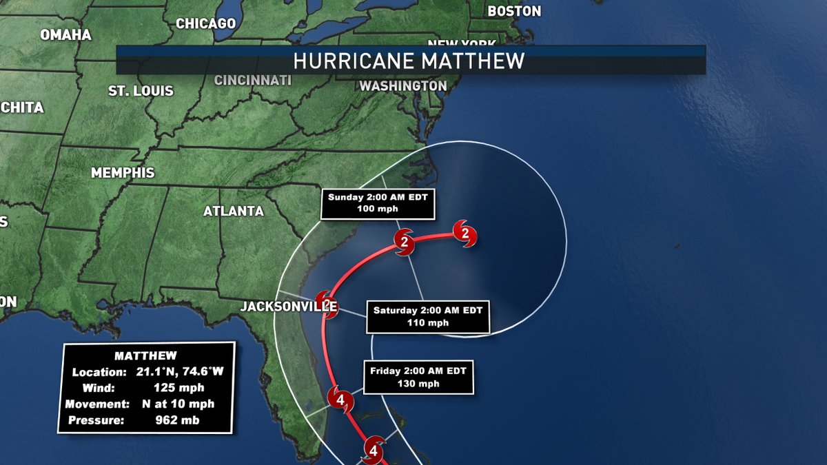
While the most current track seems to spare our region, coastal Florida will have major impacts from Hurricane Matthew. By Thursday and into Friday, Matthew should pass along the Florida coast as a Category 4 with winds of 130 mph at times.
Even if Matthew doesn’t make a direct hit on Florida, hurricane-force winds are extending about for about a 40-mile radius out of the storm, and even a little shift in track to the left or the right could have huge effects for our coastal friends. For now, this is a dangerous situation for those areas, many of which have hurricane warnings posted.
Probability of winds over 39 mph. Look at the color table for percentages. (National Hurricane Center)
Probability of winds over 39 mph. Look at the color table for percentages. (National Hurricane Center)
Although this is the latest track, it is still subject to change as we are several days out. The picture will become clearer today and tomorrow.
The only wildcard is now looks to be Tropical Storm Nicole. It’s out in the Atlantic with no immediate threat to any land, but some guidance suggests that Matthew could absorb Nicole as it moves north, or that it could almost bounce off Nicole and move back to the south before heading toward the Florida coast for the second time.
Just keep an eye out. Although Matthew is trending a little further out to sea, I wouldn’t take this as gospel quite yet. Things can still change and we need to be conscious of that.
As for our forecast, the front that will move through on Saturday seems like it will help force Matthew to the south of our region. The only other change we have now would bring some showers into the region on Friday ahead of the frontal system. That could prove to be troublesome for the Nationals’ first playoff game, but it looks like anything we see would be on the lighter side.
Total rainfall accumulation projections through Monday morning. The southeastern coastline will be the heaviest hit, with some rain accumulation in the WTOP listening area from a frontal passage.
Total rainfall accumulation projections through Monday morning. The southeastern coastline will be the heaviest hit, with some rain accumulation in the WTOP listening area from a frontal passage.
Again, this is a fluid situation, and we will continue to update you as it unfolds and new information becomes available.
http://wtop.com/weather/2016/10/hurricane-matthew-looks-hug-east-coast/
Edited 1 time(s). Last edit at 10/05/2016 10:03AM by Fox News.
Welcome to Fairfax Underground, a project site designed to improve communication among residents of Fairfax County, VA. Feel free to post anything Northern Virginia residents would find interesting.
Hurricane Matthew is going to Make Fairfax County Wet Again (sister Nicole to follow)
Posted by:
Fox News
()
Date: October 05, 2016 09:54AM
9:50 am, October 5, 2016
62°
Well, a lot has changed overnight. The track of Hurricane Matthew has shifted once again, as expected, and the scenario is what we were hoping for around the WTOP listening area. As for areas along the southeastern portion of the United States (including Florida, South Carolina and Georgia), the projection doesn’t look good.
The track of Hurricane Matthew at 5 a.m. Oct. 5, 2016. (NBC Washington)
The track of Hurricane Matthew at 5 a.m. Oct. 5, 2016. (NBC Washington)
As of 5 a.m., Hurricane Matthew is a Category 2 hurricane with winds at 125 mph. It is currently just 65 miles north-northwest of the eastern tip of Cuba. It lost some of its strength, as expected, once it traveled over the mountainous terrain of both Haiti and Cuba; however, as it travels back out into the warm open waters of the Atlantic, some re-intensification is likely.
Different outputs show likely re-intensification of Hurricane Matthew over the next 36 to 48 hours. (National Weather Service)
Different outputs show likely re-intensification of Hurricane Matthew over the next 36 to 48 hours. (National Weather Service)
While the most current track seems to spare our region, coastal Florida will have major impacts from Hurricane Matthew. By Thursday and into Friday, Matthew should pass along the Florida coast as a Category 4 with winds of 130 mph at times.
Even if Matthew doesn’t make a direct hit on Florida, hurricane-force winds are extending about for about a 40-mile radius out of the storm, and even a little shift in track to the left or the right could have huge effects for our coastal friends. For now, this is a dangerous situation for those areas, many of which have hurricane warnings posted.
Probability of winds over 39 mph. Look at the color table for percentages. (National Hurricane Center)
Probability of winds over 39 mph. Look at the color table for percentages. (National Hurricane Center)
Although this is the latest track, it is still subject to change as we are several days out. The picture will become clearer today and tomorrow.
The only wildcard is now looks to be Tropical Storm Nicole. It’s out in the Atlantic with no immediate threat to any land, but some guidance suggests that Matthew could absorb Nicole as it moves north, or that it could almost bounce off Nicole and move back to the south before heading toward the Florida coast for the second time.
Just keep an eye out. Although Matthew is trending a little further out to sea, I wouldn’t take this as gospel quite yet. Things can still change and we need to be conscious of that.
As for our forecast, the front that will move through on Saturday seems like it will help force Matthew to the south of our region. The only other change we have now would bring some showers into the region on Friday ahead of the frontal system. That could prove to be troublesome for the Nationals’ first playoff game, but it looks like anything we see would be on the lighter side.
Total rainfall accumulation projections through Monday morning. The southeastern coastline will be the heaviest hit, with some rain accumulation in the WTOP listening area from a frontal passage.
Total rainfall accumulation projections through Monday morning. The southeastern coastline will be the heaviest hit, with some rain accumulation in the WTOP listening area from a frontal passage.
Again, this is a fluid situation, and we will continue to update you as it unfolds and new information becomes available.
http://wtop.com/weather/2016/10/hurricane-matthew-looks-hug-east-coast/
Edited 1 time(s). Last edit at 10/05/2016 10:03AM by Fox News.
Re: Hurricane Matthew is going to Make Fairfax County Wet Again (sister Nicole to follow)
Posted by:
Hurikaneready
()
Date: October 06, 2016 09:12PM
It won't even barely touch Cape Hatteras. Much of the worst will be Florida and then by Wilmington it will fizzle back out to sea.