Off-Topic :
Fairfax Underground

Welcome to Fairfax Underground, a project site designed to improve communication among residents of Fairfax County, VA. Feel free to post anything Northern Virginia residents would find interesting.
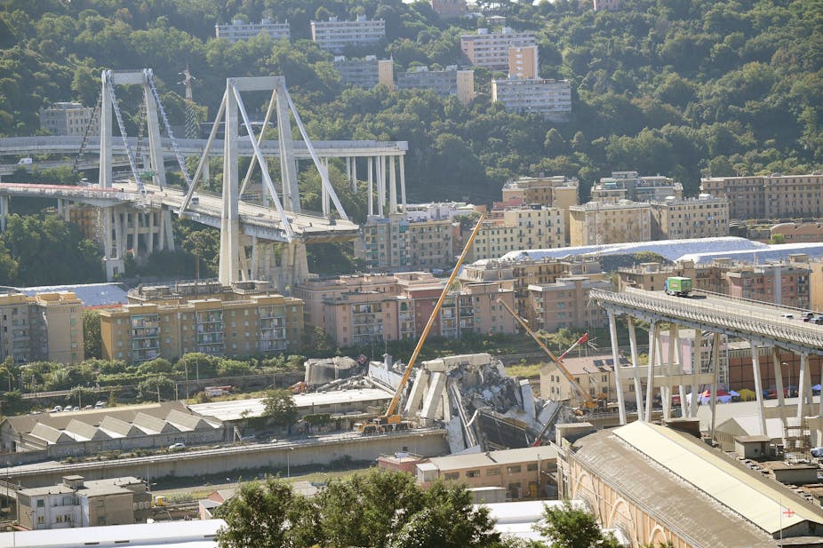 (not recent photo)
The collapse happened about Aug 14, 2018. We saw the damage then what does it look like now?
according to google maps:
* the area under the collapse now looks more like a gravel quarry than a town
* fallen road sections have "mostly" been cleared but bases of the massive pylons are still being torn down hauled away in gravel form - a massive amount remaining if they wish to "make it level for building"
* no attempt to modify the sections that did not fall are apparent
* google maps makes it appear that no buildings were damaged
The FUTURE plan by the gov is (so far, in the news) that the old sections will remain and a center span will be erected and connected (despite that they are beyond their design limit age and stressing - which isn't explained).
The standing sections on one side span over a high density apartment building complex (working on THAT section would mean paying rent for hundreds of people to evacuate them during construction).
Do you think this plan should go forward, or that they should abandon the remaining span as "too risky, old, not worth the effort to repair"?

In the big picture, the rich port side is genoa along the first river bed (now city sprawl), the bridge that collapsed is another port city along the second - which has a railroad and it's port contains some industrial traffic (for the train cargo, of course)
ALL UP AND DOWN both rivers there are road crossings - most of them modest.
The only "trouble" is this crossing. They could widen other roads and crossings and never use the crossing and not even notice.
I'm unsure about their quest to build a big ugly bridge over a port city with (good land value) where you could bike to a beautiful port.
There are opportunity for other road connections or widening all up and down that 2nd river bed. The fallen bridge and the next are at most a few miles apart.
I'm don't see good cost and benefit planning. Only a beautiful bridge of magnificent architecture would "fit" or make sense in the light that it is: not really needed.
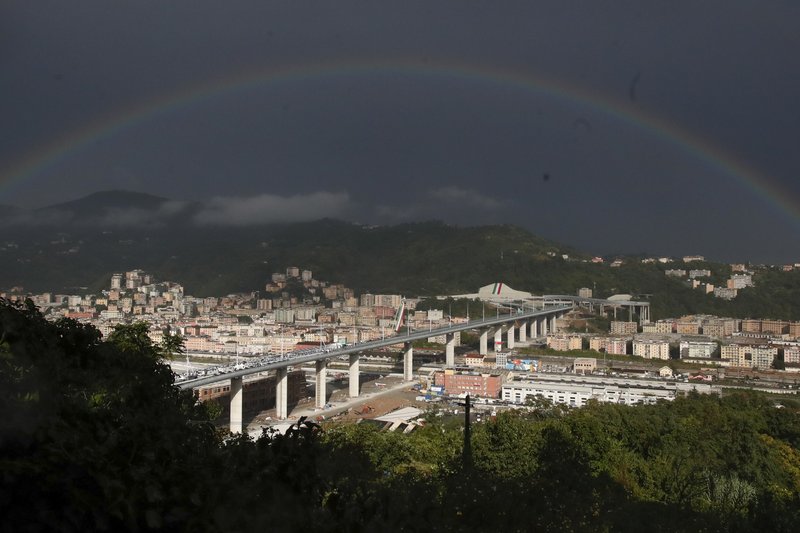
the brand spanking new bridge
Welcome to Fairfax Underground, a project site designed to improve communication among residents of Fairfax County, VA. Feel free to post anything Northern Virginia residents would find interesting.
Italy's Genoa Bridge Collapse : what is the progress ?
Posted by:
associated pressings
()
Date: August 25, 2019 02:55PM
(not recent photo)The collapse happened about Aug 14, 2018. We saw the damage then what does it look like now?
according to google maps:
* the area under the collapse now looks more like a gravel quarry than a town
* fallen road sections have "mostly" been cleared but bases of the massive pylons are still being torn down hauled away in gravel form - a massive amount remaining if they wish to "make it level for building"
* no attempt to modify the sections that did not fall are apparent
* google maps makes it appear that no buildings were damaged
The FUTURE plan by the gov is (so far, in the news) that the old sections will remain and a center span will be erected and connected (despite that they are beyond their design limit age and stressing - which isn't explained).
The standing sections on one side span over a high density apartment building complex (working on THAT section would mean paying rent for hundreds of people to evacuate them during construction).
Do you think this plan should go forward, or that they should abandon the remaining span as "too risky, old, not worth the effort to repair"?
Re: Italy's Genoa Bridge Collapse : what is the progress ?
Posted by:
associated pressings
()
Date: August 25, 2019 02:57PM
"New Genoa bridge expected to be completed by April 2020"
Re: Italy's Genoa Bridge Collapse : what is the progress ?
Posted by:
r43gt4bgrer
()
Date: August 25, 2019 03:03PM
I'm not optimistic because if they do NOT have an ingenious plan "be on a broken base", they have to either connect to the broken pylon (assuming it's cracked) or "remove and replace a deep dug old pylon" - which would be far more than a monumental task. There was news the pylons were not correct due to the flooding of the riverbed that goes under it and that the pylons "had been moving" years before any upper bridge linkage failure. The ingenuity would have to re-use a pylon known to "have movement" and make up for the connection being weaker than the original pour.
On the other hand if they dig out the old pylon - they aren't going to finish by apr 2020 i imagine.
On the other hand if they dig out the old pylon - they aren't going to finish by apr 2020 i imagine.
Re: Italy's Genoa Bridge Collapse : what is the progress ?
Posted by:
a fine eye for loosers
()
Date: August 25, 2019 03:10PM
there are "computer renderings" showing a new bridge that has NO suspension and all apartment buildings to either side and under have "vanished"
MY EXPERIENCE WITH THESE IS THAT SUBMITTED RENDERINGS, EVEN BY GOVERNMENTS, ARE LIES
THE OUTCOME IS HIGHLY UNLIKELY TO BE ANYTHING LIKE WHAT THE CONTRACTED SUBMISSIONS ARE
.
MY EXPERIENCE WITH THESE IS THAT SUBMITTED RENDERINGS, EVEN BY GOVERNMENTS, ARE LIES
THE OUTCOME IS HIGHLY UNLIKELY TO BE ANYTHING LIKE WHAT THE CONTRACTED SUBMISSIONS ARE
.
Re: Italy's Genoa Bridge Collapse : what is the progress ?
Posted by:
associated pressings
()
Date: August 25, 2019 03:17PM
> "New Genoa bridge expected to be completed by April 2020"
The bridge builders, to keep schedule, could simply ignore any obsession with the re-use or removal of old pylons and build new pylons in different spots. However: land owners are no doubt suing to have debris removed - and that will bump their schedules.
It took 6 months for the "real cleanup effort" to begin some reported. Another report says "new bridge in 1 yr from now". Hard to believe.
.
Re: Italy's Genoa Bridge Collapse : what is the progress ?
Posted by:
associated pressings
()
Date: August 25, 2019 03:34PM
In the big picture, the rich port side is genoa along the first river bed (now city sprawl), the bridge that collapsed is another port city along the second - which has a railroad and it's port contains some industrial traffic (for the train cargo, of course)
ALL UP AND DOWN both rivers there are road crossings - most of them modest.
The only "trouble" is this crossing. They could widen other roads and crossings and never use the crossing and not even notice.
I'm unsure about their quest to build a big ugly bridge over a port city with (good land value) where you could bike to a beautiful port.
There are opportunity for other road connections or widening all up and down that 2nd river bed. The fallen bridge and the next are at most a few miles apart.
I'm don't see good cost and benefit planning. Only a beautiful bridge of magnificent architecture would "fit" or make sense in the light that it is: not really needed.
Re: Italy's Genoa Bridge Collapse : what is the progress ?
Posted by:
associated pressings
()
Date: August 25, 2019 03:38PM
To be clear: there are already bridges all up and down that 2nd river bed, roads crossing the old river all up and down too. The one that fell does connect two major roads but that spot that bridge is far from the only opportunity to do so, far from. And the distances being discussed also are simply not very far - minutes of travel.
Re: Italy's Genoa Bridge Collapse : what is the progress ?
Posted by:
watch your diet
()
Date: August 25, 2019 04:19PM
Where are all the goats? If that's Genoa where is the salami in my sandwich coming from ??
Re: Italy's Genoa Bridge Collapse : what is the progress ?
Posted by:
344hg
()
Date: December 18, 2020 04:55PM
the brand spanking new bridge
Re: Italy's Genoa Bridge Collapse : what is the progress ?
Posted by:
rberbt
()
Date: December 18, 2020 04:56PM
Genoa has new bridge 2 years after collapse that killed 43
By LUCA BRUNO, ANTONIO CALANNI and FRANCES D'EMILIO
August 3, 2020
https://apnews.com/article/genoa-italy-bridge-collapses-travel-virus-outbreak-864ac18493ce333d9c54856d7b24238b
By LUCA BRUNO, ANTONIO CALANNI and FRANCES D'EMILIO
August 3, 2020
https://apnews.com/article/genoa-italy-bridge-collapses-travel-virus-outbreak-864ac18493ce333d9c54856d7b24238b