Fairfax County General :
Fairfax Underground

Welcome to Fairfax Underground, a project site designed to improve communication among residents of Fairfax County, VA. Feel free to post anything Northern Virginia residents would find interesting.
Welcome to Fairfax Underground, a project site designed to improve communication among residents of Fairfax County, VA. Feel free to post anything Northern Virginia residents would find interesting.
Re: Dollar Tree on Maple Avenue in Vienna is now open!
Posted by:
Gayvid Blimmo.
()
Date: October 14, 2020 12:34PM
Actual JP Morgenthau Wrote:
-------------------------------------------------------
>
>
>
> There is still a way
> to save the country, if only we will pull together
> and take it.
>
>
YOU'RE RIGHT! We all have to wake up and vote for DONALD TRUMP FOR PRESIDENT!!!!!!!!!
We have to keep Sleepy Joe out of the White House b\c Sleepy Joe is controlled by the radical left. It's time to vote out Nazi Pelousy, Screwball Schumer & Durbin with a Turban.
Remember, vote for DONALD TRUMP FOR PRESIDENT!!!!!!!!. Deport the nutjob lefties to Iran, North Korea, Cuba and Venn-ezz-WAY-luh!
America for REAL AMERICANS! Socialist Paradise of Venezuela for socialist Democrats! Iran & NK for terrorist loving Democrats!
Sorry 4 being redundant. I said "socialist" and "terrorist loving" Democrats.
Re: Dollar Tree on Maple Avenue in Vienna is now open!
Posted by:
seven figure city...
()
Date: October 14, 2020 12:42PM
Actual JP Morgenthau Wrote:
-------------------------------------------------------
> That's some really bad butthurt there, Bozo.
> Maybe console yourself with a long, lonely walk
> off into the wilds of Arlington to find some
> top-of-your-class strip-mall Mediterranean food.
No butthurt. The August 2019 photos royally fucked you. Your contentions regarding views of the glass and granite walls of the American Veterans Disabled for Life Memorial were thoroughly obliterated by the photos and the month and year they were taken. They make your claims of what you allegedly saw in October completely impossible. The photo shows you are at worst a liar and at best mistaken about what you saw. Well, which is it?
Re: Dollar Tree on Maple Avenue in Vienna is now open!
Posted by:
Actual JP Morgenthau
()
Date: October 14, 2020 02:09PM
Captain goes down with the ship! Over and over and over again. By the way, is that ‘hammer’ of yours anything like the list of daily specials at #4 that you were threatening to release not so long ago? What a thoroughly empty vessel!
Re: Dollar Tree on Maple Avenue in Vienna is now open!
Posted by:
seven figure city...
()
Date: October 14, 2020 02:19PM
The photo was taken in 2019. Your contentions are total bullshit. You do realize that Google tells folks when and where their fleet of vehicles will be out capturing street-view images, don't you?
https://www.google.com/streetview/explore/
You're about to be fucked even more than you already are. Just admit you lied or made a mistake. Save yourself from further embarrassment.
https://www.google.com/streetview/explore/
You're about to be fucked even more than you already are. Just admit you lied or made a mistake. Save yourself from further embarrassment.
Re: Dollar Tree on Maple Avenue in Vienna is now open!
Posted by:
Actual JP Morgenthau
()
Date: October 14, 2020 02:31PM
Sorry, Bozo! Your unwarranted assumptions were baseless and unfounded. You’ve only made a jerk of yourself yet again.
Re: Dollar Tree on Maple Avenue in Vienna is now open!
Posted by:
seven figure city....
()
Date: October 14, 2020 02:45PM
They were not assumptions. They were facts. You do realize that Google tells folks when and where their fleet of vehicles will be out capturing street-view images, don't you?
https://www.google.com/streetview/explore/
https://www.google.com/streetview/explore/
Re: Dollar Tree on Maple Avenue in Vienna is now open!
Posted by:
Actual JP Morgenthau
()
Date: October 14, 2020 02:50PM
seven figure city... Wrote:
-------------------------------------------------------
> The photo was taken in 2019. Your contentions are total bullshit.
My contentions are based first on the fact that I was there on three days in October 2019 when views were not at all like what is suggested in your photo, and second on the fact that you don’t know any more about Google’s handling of your misleading photo-phoniness than you do about dining at Fiola Mare. Which of course would come to nothing at all.
Re: Dollar Tree on Maple Avenue in Vienna is now open!
Posted by:
seven figure city....
()
Date: October 14, 2020 02:55PM
Actual JP Morgenthau Wrote:
-------------------------------------------------------
> My contentions are based first on the fact that I
> was there on three days in October 2019 when views
> were not at all like what is suggested in your
> photo,
Your contentions are based on lies. Either you lied about being there or you lied about what you saw. The only difference is that views in October would include views of the trees taking on their autumn gold color. In fact, the views of the glass and granite walls still aren't obstructed and they never have been.
> and second on the fact that you don’t
> know any more about Google’s handling of your
> misleading photo-phoniness than you do about
> dining at Fiola Mare.
Well, too bad for you that I know far more about both of those than you could ever dream to. You're totally fucked. You do realize that Google tells folks when and where their fleet of vehicles will be out capturing street-view images, don't you?
https://www.google.com/streetview/explore/
That little nugget right there should give you pause, but you are too dumb to stop lying now.
Re: Dollar Tree on Maple Avenue in Vienna is now open!
Posted by:
Actual JP Morgenthau
()
Date: October 14, 2020 03:14PM
seven figure city.... Wrote:
----------------------------------------------
> Your contentions are based on lies.
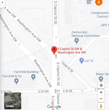
Unlike you, I have often driven past the AVDL Memorial site, and it looks like I will next do so a week from this Saturday. As you would not know except for my having told you, views along Wash Ave have changed considerably over the summer, so we will have to see what this next journey holds. It will certainly however confirm that the intersection with S Cap is south of the RR tracks.
----------------------------------------------
> Your contentions are based on lies.
Unlike you, I have often driven past the AVDL Memorial site, and it looks like I will next do so a week from this Saturday. As you would not know except for my having told you, views along Wash Ave have changed considerably over the summer, so we will have to see what this next journey holds. It will certainly however confirm that the intersection with S Cap is south of the RR tracks.
Re: Dollar Tree on Maple Avenue in Vienna is now open!
Posted by:
Dear Asshole...
()
Date: October 14, 2020 04:41PM
You're full of shit.
"When viewing a Street View panorama, you can see the month and year a panorama was collected at the bottom of the screen."
Love,
Google

"When viewing a Street View panorama, you can see the month and year a panorama was collected at the bottom of the screen."
Love,
Re: Dollar Tree on Maple Avenue in Vienna is now open!
Posted by:
seven figure city....
()
Date: October 14, 2020 05:52PM
Actual JP Morgenthau Wrote:
-------------------------------------------------------
> Unlike you, I have often driven past the AVDL
> Memorial site, and it looks like I will next do so
> a week from this Saturday.
LOL! You've claimed as much, but a quick look at my calendar confirms I was in the area at least quadruple the times in October that you alleged you were. I've been there dozens of times since and countless times before that. It's for this very reason you continually get your ass stomped every time you mangle a description of the features and roads of the area. Let's recall exit 6, 12+ foot walls the slip lane from S. Capitol St. to Washington Avenue entirely north of the tracks, large asphalt parking lots and list goes on and on.
Now, let's just blow your little story about the date being mislabeled in the August 2019 photograph. As you should be aware by now, Google tells folks when and where their fleet of vehicles will be out capturing street-view images.
https://www.google.com/streetview/explore/
If we use a little bit of internet magic, we can use a time machine to see where the Google street-view team might have been in the summer of 2019.
https://web.archive.org/web/20190812122935/https://www.google.com/streetview/explore/
Well, look at that! Google indicated it would be in Washington, DC taking street view imagery between April and November of 2019. What was the date on that photo of the memorial we have been discussing? Oh yeah, August 2019. Imagine that, it falls right within the timeframe Google told folks it would be in DC.
So, on the one hand, we have the contention of a confirmed liar about all these views being obscured my unmanaged foliage. Who then when cornered concocted this massive pruning operation by NPS.
On the other hand, I've actually been to the place dozens of times since your alleged trips and can report your stories are complete bullshit. We have a Google street-view picture indicating it was captured in August of 2019. There is no credible evidence to contradict that information found on the image. Additionally, we now have evidence that Google indicated it would be conducting street-view operations in Washington, DC between April and November of 2019.
Your honor, seeing as no reasonable jury would ever believe the lies of this asshole and all available evidence shows he is lying, I move for a directed verdict.
JUDGE: Granted, he's definitely lying and caught red handed doing it. He's sentenced to being labeled a liar.
> As you would not know
> except for my having told you, views along Wash
> Ave have changed considerably over the summer,
No. They didn't. There was no large-scale pruning event conducted my NPS. First, the trees are far too young to need pruning. Pruning, when they are mature enough to warrant pruning, is done in late fall, winter, or early spring NOT the summer. Second, it goes against the desire to have an enveloping canopy. They are still years away from that and would not slow it down with unnecessary off-season pruning. You have to be really dumb to think that anyone is buying your total bullshit.
> so
> we will have to see what this next journey holds.
> It will certainly however confirm that the
> intersection with S Cap is south of the RR tracks.
Which will confirm you didn't actually make the trip. If you had, you'd know that this part of the intersection of S. Capitol St. and Washington Avenue is entirely north of the tracks. Of course, you should have know as much when mention of a large asphalt parking lot was made. Being wholly unfamiliar with the area, you fell flat on your face.
Re: Dollar Tree on Maple Avenue in Vienna is now open!
Posted by:
seven figure city....
()
Date: October 14, 2020 05:54PM
Dear Asshole... Wrote:
-------------------------------------------------------
> You're full of shit.
>
> "When viewing a Street View panorama, you can see
> the month and year a panorama was collected at the
> bottom of the screen."
>
> Love,
>
> Google
>
>
>
> src="https://i0.wp.com/www.geoawesomeness.com/wp-c
> ontent/uploads/2017/09/Street-View-car-new.jpg?res
> ize=738%2C554&ssl=1">
Of course, he'll still keep up his attempts to bullshit his way out of it. The only thing that proves is that he is dumb enough to think anyone believes it.
-------------------------------------------------------
> You're full of shit.
>
> "When viewing a Street View panorama, you can see
> the month and year a panorama was collected at the
> bottom of the screen."
>
> Love,
>
>
>
>
> src="https://i0.wp.com/www.geoawesomeness.com/wp-c
> ontent/uploads/2017/09/Street-View-car-new.jpg?res
> ize=738%2C554&ssl=1">
Of course, he'll still keep up his attempts to bullshit his way out of it. The only thing that proves is that he is dumb enough to think anyone believes it.
Re: Dollar Tree on Maple Avenue in Vienna is now open!
Posted by:
this checks out
()
Date: October 14, 2020 10:45PM
Dear Asshole... Wrote:
-------------------------------------------------------
> You're full of shit.
>
> "When viewing a Street View panorama, you can see
> the month and year a panorama was collected at the
> bottom of the screen."
>
> Love,
>
> Google
>
>
>
> src="https://i0.wp.com/www.geoawesomeness.com/wp-c
> ontent/uploads/2017/09/Street-View-car-new.jpg?res
> ize=738%2C554&ssl=1">
https://support.google.com/earth/answer/6327779
-------------------------------------------------------
> You're full of shit.
>
> "When viewing a Street View panorama, you can see
> the month and year a panorama was collected at the
> bottom of the screen."
>
> Love,
>
>
>
>
> src="https://i0.wp.com/www.geoawesomeness.com/wp-c
> ontent/uploads/2017/09/Street-View-car-new.jpg?res
> ize=738%2C554&ssl=1">
https://support.google.com/earth/answer/6327779
Re: Dollar Tree on Maple Avenue in Vienna is now open!
Posted by:
Actual JP Morgenthau
()
Date: October 15, 2020 08:41AM
So the Whiffies are once again rattled by simple confrontation with actual fact. It happens so often that it taxes their ability to construct alternate facts -- i.e., make shit up. Street View photos come from two sources, Google and our contributors. That's according to Google. According to one who was there on three says in October 2019, views then did not align at all well with the theme suggested in the supposed August 2019 photo from whatever source. No person who had actually been there that October could honestly have found differently. And by the way, reports of 2020 pruning along Wash Ave were first made following our August visit, then updated after our September visit. We'll see in ten days or so what furthwr updates may be appropriate. In the meantime, do not forget the humiliation of...
Re: Dollar Tree on Maple Avenue in Vienna is now open!
Posted by:
seven figure city...
()
Date: October 15, 2020 09:24AM
You've claimed as much, but a quick look at my calendar confirms I was in the area at least quadruple the times in October that you alleged you were. I've been there dozens of times since and countless times before that. It's for this very reason you continually get your ass stomped every time you mangle a description of the features and roads of the area. Let's recall exit 6, 12+ foot walls the slip lane from S. Capitol St. to Washington Avenue entirely north of the tracks, large asphalt parking lots and list goes on and on.
Now, let's just blow your little story about the date being mislabeled in the August 2019 photograph out of the water. As you should be aware by now, Google tells folks when and where their fleet of vehicles will be out capturing street-view images.
https://www.google.com/streetview/explore/
If we use a little bit of internet magic, we can use a time machine to see where the Google street-view team might have been in the summer of 2019.
https://web.archive.org/web/20190812122935/https://www.google.com/streetview/explore/
Well, look at that! Google indicated it would be in Washington, DC taking street view imagery between April and November of 2019. What was the date on that photo of the memorial we have been discussing? Oh yeah, August 2019. Imagine that, it falls right within the timeframe Google told folks it would be in DC.
So, on the one hand, we have the contention of a confirmed liar about all these views being obscured my unmanaged foliage. Who then when cornered concocted this massive pruning operation by NPS.
On the other hand, I've actually been to the place dozens of times since your alleged trips and can report your stories are complete bullshit. We have a Google street-view picture indicating it was captured in August of 2019. There is no credible evidence to contradict that information found on the image. Additionally, we now have evidence that Google indicated it would be conducting street-view operations in Washington, DC between April and November of 2019. Finally, we have Google verifying that month and year the photo was taken can be found at the bottom of the screen. https://support.google.com/earth/answer/6327779
Short version: you lied and you got caught doing so.
As for pruning, there was no large-scale pruning event conducted my NPS. First, the trees are far too young to need pruning. Pruning, when they are mature enough to warrant pruning, is done in late fall, winter, or early spring NOT the summer. Second, it goes against the desire to have an enveloping canopy. They are still years away from that and would not slow it down with unnecessary off-season pruning. You have to be really dumb to think that anyone is buying your total bullshit.
Re: Dollar Tree on Maple Avenue in Vienna is now open!
Posted by:
seven figure city...
()
Date: October 15, 2020 09:30AM
Almost forgot. What are the names of the streets intersecting to the left of the traffic island in the picture below? Funny how photos provide much more detail than maps with thumbtacks in them.
Re: Dollar Tree on Maple Avenue in Vienna is now open!
Posted by:
Actual JP Morgenthau
()
Date: October 15, 2020 10:01AM
Well, I know the costs in terms of raging envy and butthurt that would be unleashed pursuant to reports of any dining out at popular Reston dining spots last night, so I won't mention those. Instead, I will simply confirm that it is yet another beautiful autumn morning out here in the ever delightful and widely envied Sweet Spot. It was a refreshingly cool 54 degrees out there when I first got up, as the trip out and back to collect the morning paper saw nothing but warm sunshine, gentle southerly breezes, just a tad too much humidity, but still great expectations for another wonderful day. Wildlife sightings have been down quite a bit here recently, so it would appear that there is something more than just nibbling on local green goods for them to be concerned over. It's just that time of year.
It's getting closer and closer to the time when all true Americans must by whatever means contribute to the unelection of the dismal and destructive President Ding Dong, an obese monster whose awful treachery and dereliction of duty have equally brought massive pain, suffering, and calamity into virtually every aspect of American life. The demon must be driven off, and each of us has a role we can play in that, so don't neglect your own. Uncle Sam Needs You!
In other news, not much other than phony-ball silliness is going on just now. MASN isn't even being allowed to air Nats Classics during watchable hours these days. Just another visitation of ugliness upon the fans who pay the freight perpetrated by the despicable Bozo Bobby Manfred, another thoroughly awful person.
More of those are of course to be found within the fitful confines of Falls Church City. People there face a complete lack of branzino at their local pizzeria, and some have even reported having to walk miles and miles simply to order strip-mall Mediterranean food. It's like Peruvian Chicken might be seen as some sort of delicacy there, with denizens forced into either real or completely fabricated travel out of town in order to find any sort of decent dining at all. Why any but fools would remain in such a place is quite a difficult thing to fathom.
Re: Dollar Tree on Maple Avenue in Vienna is now open!
Posted by:
seven figure city.....
()
Date: October 15, 2020 10:50AM
^^^^^no doubt more bullshit to distract from his lies. Even when caught in his lies, he just keeps lying.
Re: Dollar Tree on Maple Avenue in Vienna is now open!
Posted by:
Actual JP Morgenthau
()
Date: October 15, 2020 10:59AM
^^^ El grande perdedor once his hanging on my every word was finally rewarded.
Re: Dollar Tree on Maple Avenue in Vienna is now open!
Posted by:
seven figure city....
()
Date: October 15, 2020 11:54AM
Your Spanish is just as bad as your English. No doubt you'll lie about that. Remember, this picture was captured in 2019 and it proves you are a liar.

Now, let's just blow your little story about the date being mislabeled in the August 2019 photograph out of the water. As you should be aware by now, Google tells folks when and where their fleet of vehicles will be out capturing street-view images.
https://www.google.com/streetview/explore/
If we use a little bit of internet magic, we can use a time machine to see where the Google street-view team might have been in the summer of 2019.
https://web.archive.org/web/20190812122935/https://www.google.com/streetview/explore/
Well, look at that! Google indicated it would be in Washington, DC taking street view imagery between April and November of 2019. What was the date on that photo of the memorial we have been discussing? Oh yeah, August 2019. Imagine that, it falls right within the timeframe Google told folks it would be in DC.
Re: Dollar Tree on Maple Avenue in Vienna is now open!
Posted by:
Actual JP Morgenthau
()
Date: October 15, 2020 12:16PM
My facility with Spanish would place it fifth on my resume. Might still be as good as your pathetic English. And as was noted earlier, there is no actual connection between the date you cite and the actual date on which an image was created. Actual and repeated in-person checks concerning the validity of this photo in particular have called it into very serious question.
Re: Dollar Tree on Maple Avenue in Vienna is now open!
Posted by:
seven figure city....
()
Date: October 15, 2020 12:37PM
Actual JP Morgenthau Wrote:
-------------------------------------------------------
> there is no
> actual connection between the date you cite and
> the actual date on which an image was created.
LOL! Of course there is. The date I cite is the date indicated by Google on its "image captured" portion of the photo. Further, Google even indicated that they would bee capturing street view images in DC between April and November of 2019.
https://web.archive.org/web/20190812122935/https://www.google.com/streetview/explore/
The photo in question was Captured in August of 2019 and that falls within that timeframe. Your attempt to nullify that fact is both ridiculously stupid and unsupported by fact. After all, Google even indicates that "when viewing a Street View panorama, you can see the month and year a panorama was collected at the bottom of the screen." https://support.google.com/earth/answer/6327779
Your alleged visits are the only thing called into very serious question. They are called into question by those who actually visited (including me) the location in the timeframe you suggest and by the photo captured in August of 2019.
Finally, there was no large-scale pruning event conducted my NPS. First, the trees are far too young to need pruning. Pruning, when they are mature enough to warrant pruning, is done in late fall, winter, or early spring NOT the summer. You are basically accusing NPS of horticultural malpractice. Second, it goes against the desire to have an enveloping canopy. They are still years away from that and would not slow it down with unnecessary off-season pruning. You have to be really dumb to think that anyone is buying your total bullshit.
Re: Dollar Tree on Maple Avenue in Vienna is now open!
Posted by:
Actual JP Morgenthau
()
Date: October 15, 2020 01:17PM
^^^ All of that is just your usual rubbish.
Re: Dollar Tree on Maple Avenue in Vienna is now open!
Posted by:
Rookie Mistake
()
Date: October 15, 2020 01:25PM
Actual JP Morgenthau Wrote:
-------------------------------------------------------
> Street View photos come from two sources, Google and our
> contributors. That's according to Google.
Yes. But that's only where they don't have actual captures from their own Street View units. NOt the case here.
See, that's what happens when you don't really understand what you're talking about. Happens to you a lot.
Re: Dollar Tree on Maple Avenue in Vienna is now open!
Posted by:
seven figure city...
()
Date: October 15, 2020 01:39PM
Actual JP Morgenthau Wrote:
-------------------------------------------------------
> ^^^ All of that is just your usual rubbish.
All that is just my usual facts. None if which you can credibly dispute. What incentive does Google have to misrepresent the "image captured" date? The answer is none. Your the only one in the world that needs that date to be wrong. Unfortunately for you, it is 100% accurate.
Face it, you are a liar and you got caught lying. The only question that remains us are you going to keep lying?
Re: Dollar Tree on Maple Avenue in Vienna is now open!
Posted by:
Actual JP Morgenthau
()
Date: October 15, 2020 01:46PM
Cringe-worthy blabber posted by one with a serious truth-allergy.
Re: Dollar Tree on Maple Avenue in Vienna is now open!
Posted by:
seven figure city...
()
Date: October 15, 2020 01:57PM
Dude, there is no way out of this for you. If you're stupid enough to believe that people think Google is wrong about the timestamp on their photo and you are somehow correct, you're dumber that I thought.
Google said they'd be capturing street view images un DC between April and November 2019. The photo is labeled as being captured in August of 2019. It all adds up. The only thing that doesn't add up is your tall tale about the views around that time.
You got caught lying. That part is over. It's a done deal. Are you man enough to admit it? My guess is you're not.
Re: Dollar Tree on Maple Avenue in Vienna is now open!
Posted by:
Actual JP Morgenthau
()
Date: October 15, 2020 02:16PM
REFRESHER FOR THE SERIOUSLY DUMB
--------------------------------------------------
Since you plainly do not know, there is no connection at all
between these dates you cite and the date on which an image
was actually taken. The date is applied ad hoc,not by Google,
but by image contributors, with most simply filling in a copyright
date. Google simply goes along for the ride. Individual dates are
not used because so many photos are actually stitched together
from multiple submissions from the same general timeframe.
Your fervent August 2019 claim is thus just baseless noise,
which goes a long way toward explaining why in-person views
from that October could be so meaningfully different.
Re: Dollar Tree on Maple Avenue in Vienna is now open!
Posted by:
Actual JP Morgenthau
()
Date: October 15, 2020 02:28PM
seven figure city... Wrote:
-------------------------------------------------------
> Dude, there is no way out of this for you. If you're stupid
> enough to believe that people think Google is wrong about
> the timestamp on their photo and you are somehow correct,
> you're dumber that I thought.
Google does not claim what you claim. You are the one who is fucked up here.
Re: Dollar Tree on Maple Avenue in Vienna is now open!
Posted by:
seven figure city...
()
Date: October 15, 2020 03:02PM
Google claims it was collecting street view imagery between April and November of 2019.
Google claims that "when viewing a Street View panorama, you can see the month and year a panorama was collected at the bottom of the screen."
All available evidence supports my claims. All available evidence refutes your claims. You lied. You got caught.
Google claims that "when viewing a Street View panorama, you can see the month and year a panorama was collected at the bottom of the screen."
All available evidence supports my claims. All available evidence refutes your claims. You lied. You got caught.
Re: Dollar Tree on Maple Avenue in Vienna is now open!
Posted by:
Actual JP Morgenthau
()
Date: October 15, 2020 03:14PM
^^^ Another typical mish-mash of stupid bullshit. You messed up on north-south and then on August 2019. So much of what was in between was pure slop also.
Re: Dollar Tree on Maple Avenue in Vienna is now open!
Posted by:
seven figure city...
()
Date: October 15, 2020 03:33PM
Actual JP Morgenthau Wrote:
-------------------------------------------------------
> ^^^ Another typical mish-mash of stupid bullshit.
> You messed up on north-south and then on August
> 2019. So much of what was in between was pure
> slop also.
All facts that you can't dispute. Liar.
-------------------------------------------------------
> ^^^ Another typical mish-mash of stupid bullshit.
> You messed up on north-south and then on August
> 2019. So much of what was in between was pure
> slop also.
All facts that you can't dispute. Liar.
Re: Dollar Tree on Maple Avenue in Vienna is now open!
Posted by:
Actual JP Morgenthau
()
Date: October 15, 2020 04:03PM
Your facts ain’t nothing but trash.
Re: Dollar Tree on Maple Avenue in Vienna is now open!
Posted by:
Actual JP Morgenthau
()
Date: October 15, 2020 04:35PM
By the way, we are out again to pick up dinner from a strip-mall
Pizzeria. But not the one you might think.
Edited 1 time(s). Last edit at 10/15/2020 04:35PM by Actual JP Morgenthau.
Pizzeria. But not the one you might think.
Edited 1 time(s). Last edit at 10/15/2020 04:35PM by Actual JP Morgenthau.
Re: Dollar Tree on Maple Avenue in Vienna is now open!
Posted by:
seven figure city....
()
Date: October 15, 2020 05:55PM
Actual JP Morgenthau Wrote:
-------------------------------------------------------
> Your facts ain’t nothing but trash.
My facts are straight from the horse's mouth.
Google claimed they were in DC collecting street view images between April and November of 2019 - https://web.archive.org/web/20190812122935/https://www.google.com/streetview/explore/
Google tells folks that when they are "viewing a Street View panorama, you can see the month and year a panorama was collected at the bottom of the screen." - https://support.google.com/earth/answer/6327779
The photo indicates the image was captured in August 2019.
Face it, you're fucked. Everyone can see that you are a liar and there isn't a damn thing you can do about it. You're a total fraud and everyone knows it. Sucks to be you.
Re: Dollar Tree on Maple Avenue in Vienna is now open!
Posted by:
Same shit, different day
()
Date: October 15, 2020 05:57PM
He knows he fucked up.
Again.
Again.
Re: Dollar Tree on Maple Avenue in Vienna is now open!
Posted by:
seven figure city....
()
Date: October 15, 2020 05:58PM
Actual JP Morgenthau Wrote:
-------------------------------------------------------
> By the way, we are out again to pick up dinner
> from a strip-mall
> Pizzeria. But not the one you might think.
LOL! 4:35. Are you going out for the early-bird special, old-timer? Meanwhile, over in the real world, the confirmation text for dinner reservations tomorrow came in and was replied to. Maybe you can find another early-bird special then! LOL!
Re: Dollar Tree on Maple Avenue in Vienna is now open!
Posted by:
seven figure city....
()
Date: October 15, 2020 06:26PM
LOL! It's just not your day. Guess who is serving branzino as their special today?
https://direct.chownow.com/order/20901/locations/30249
And no, dope, that is not a chowhound menu. It is the takeout menu for Pizzeria Orso.
Grilled Branzino
chimichuri salsa, fingerling potatoes, spinach, lemon, capers
Grilled no less! LOL!
Well, they've been known to do that from time to time over at Orso!
Just pack it in for the day, you just can't win.
Re: Dollar Tree on Maple Avenue in Vienna is now open!
Posted by:
seven figure city....
()
Date: October 15, 2020 06:27PM
Same shit, different day Wrote:
-------------------------------------------------------
> He knows he fucked up.
>
> Again.
To make matters worse for him, they're serving grilled branzino over at Orso today.
https://direct.chownow.com/order/20901/locations/30249
-------------------------------------------------------
> He knows he fucked up.
>
> Again.
To make matters worse for him, they're serving grilled branzino over at Orso today.
https://direct.chownow.com/order/20901/locations/30249
Re: Dollar Tree on Maple Avenue in Vienna is now open!
Posted by:
Actual JP Morgenthau
()
Date: October 15, 2020 06:40PM
LOL! You ain’t no Dr. Dolittle. This horse of yours is just shoveling shit up your ass. Stupid to let that happen, but stupid is most of all that you do.
Meanwhile, we were in the area already to get some financial papers notarized, so we decided to pop on over and get two birds killed with one stone. It’s just another case of making the best of a good situation.
Meanwhile, we were in the area already to get some financial papers notarized, so we decided to pop on over and get two birds killed with one stone. It’s just another case of making the best of a good situation.
Re: Dollar Tree on Maple Avenue in Vienna is now open!
Posted by:
Actual JP Morgenthau
()
Date: October 15, 2020 06:46PM
seven figure city.... Wrote:
--------------------------------------------------
> To make matters worse for him, they're serving
> grilled branzino over at Orso today.
Hell has frozen over. Won’t have been prepared on a proper grill though.
--------------------------------------------------
> To make matters worse for him, they're serving
> grilled branzino over at Orso today.
Hell has frozen over. Won’t have been prepared on a proper grill though.
Re: Dollar Tree on Maple Avenue in Vienna is now open!
Posted by:
seven figure city....
()
Date: October 15, 2020 06:47PM
Actual JP Morgenthau Wrote:
-------------------------------------------------------
> LOL! You ain’t no Dr. Dolittle. This horse of
> yours is just shoveling shit up your ass. Stupid
> to let that happen, but stupid is most of all that
> you do.
Wrong, asshole. The horse is trampling you. Some might call what I am doing to you beating a dead horse, but your lying ass deserves it.
Google claimed they were in DC collecting street view images between April and November of 2019 - https://web.archive.org/web/20190812122935/https://www.google.com/streetview/explore/
Google tells folks that when they are "viewing a Street View panorama, you can see the month and year a panorama was collected at the bottom of the screen." - https://support.google.com/earth/answer/6327779
The photo indicates the image was captured in August 2019.
Everyone knows you are a liar. Now, you are just proving to them you are stupid by thinking you can lie your way out of it. Talk about digging the hole deeper.
> Meanwhile, we were in the area already to get some
> financial papers notarized, so we decided to pop
> on over and get two birds killed with one stone.
> It’s just another case of making the best of a
> good situation.
LOL! If you think getting documents notarized is a "good situation" your life is pure shit.
Re: Dollar Tree on Maple Avenue in Vienna is now open!
Posted by:
seven figure city....
()
Date: October 15, 2020 06:50PM
Actual JP Morgenthau Wrote:
-------------------------------------------------------
> seven figure city.... Wrote:
> --------------------------------------------------
>
> > To make matters worse for him, they're serving
> > grilled branzino over at Orso today.
>
> Hell has frozen over.
Nope. Just more proof you are a liar and a fraud. When it rains it pours!
> Won’t have been prepared
> on a proper grill though.
Sure it is. You have no clue what sort of grill they have. Hell, you don't even know what a "proper" grill is.
Re: Dollar Tree on Maple Avenue in Vienna is now open!
Posted by:
Actual JP Morgenthau
()
Date: October 15, 2020 07:55PM
^^^ Like a dog chasing its own tail. One who is not at a level of understanding the functions of a notary. Pizza and salad were delicious, by the way. Half a pie left over for breakfast too. Mighty nice.
Re: Dollar Tree on Maple Avenue in Vienna is now open!
Posted by:
seven figure city...
()
Date: October 15, 2020 08:04PM
LOL! There is no joy in going to get something notarized, dope. You're a liar and a fraud.
Re: Dollar Tree on Maple Avenue in Vienna is now open!
Posted by:
Actual JP Morgenthau
()
Date: October 16, 2020 08:03AM
seven figure city.... Wrote:
-------------------------------------------------------
> Google claimed they were in DC collecting street
> view images between April and November of 2019
They may have been. But the disparity between what is supposed by some to be an August photo and multiple October eyewitness reports is so great as to strain credulity.
> Google tells folks that when they are "viewing a
> Street View panorama, you can see the month and
> year a panorama was collected at the bottom of the
> screen." -
What they actually say there is that 'If you’re looking for more information about when an image was collected, contact the original provider of that dataset. Image providers are shown in copyright dates. Google is not able to provide any more information about imagery it owns beyond what is displayed in Google Earth and Maps.' The dates you cite simply are not what you foolishly want to believe them to be.
Re: Dollar Tree on Maple Avenue in Vienna is now open!
Posted by:
Actual JP Morgenthau
()
Date: October 16, 2020 08:11AM
seven figure city.... Wrote:
-------------------------------------------------------
> Nope. Just more proof you are a liar and a fraud.
So your 'from time to time' was actually meant to be 'once every few years?' Pizzeria Orso at one time and under a different chef did regularly serve branzino. Those days long ago drifted off into the mists of the past without your ever noticing. The is so much that gets by you.
Re: Dollar Tree on Maple Avenue in Vienna is now open!
Posted by:
Actual JP Morgenthau
()
Date: October 16, 2020 08:23AM
seven figure city... Wrote:
-------------------------------------------------------
> LOL! There is no joy in going to get something
> notarized, dope. You're a liar and a fraud.
It's an ordinary part of doing business. Even non-profit business. It is a common means of assuring the integrity and authenticity of hard copy documents. Your failure to be at a level where this can be important is not really something to be boasting of.
Re: Dollar Tree on Maple Avenue in Vienna is now open!
Posted by:
seven figure city....
()
Date: October 16, 2020 10:06AM
Actual JP Morgenthau Wrote:
-------------------------------------------------------
> seven figure city... Wrote:
> --------------------------------------------------
> -----
> > LOL! There is no joy in going to get something
> > notarized, dope. You're a liar and a fraud.
>
> It's an ordinary part of doing business. Even
> non-profit business. It is a common means of
> assuring the integrity and authenticity of hard
> copy documents.
Exactly, there is no pleasure derived from it. It isn't a bad situation or a good situation. It is what it is. You misspoke. It won't be the only blunder or lie you are caught in today.
August 2019

October 2018

July 2017

LOL! Your contentions aren't even remotely plausible, liar.
And let's not forget what appeared at Orso yesterday.

Nothing but lies from your lying ass.
-------------------------------------------------------
> seven figure city... Wrote:
> --------------------------------------------------
> -----
> > LOL! There is no joy in going to get something
> > notarized, dope. You're a liar and a fraud.
>
> It's an ordinary part of doing business. Even
> non-profit business. It is a common means of
> assuring the integrity and authenticity of hard
> copy documents.
Exactly, there is no pleasure derived from it. It isn't a bad situation or a good situation. It is what it is. You misspoke. It won't be the only blunder or lie you are caught in today.
August 2019
October 2018
July 2017
LOL! Your contentions aren't even remotely plausible, liar.
And let's not forget what appeared at Orso yesterday.
Nothing but lies from your lying ass.
Re: Dollar Tree on Maple Avenue in Vienna is now open!
Posted by:
Actual JP Morgenthau
()
Date: October 16, 2020 10:44AM
Well, the Whiffies have once again failed to show sense enough to come in out of the rain. Badly bruised and battered, they can only jabber on all but incoherently about the state of their own sorry misunderstandings, hoping somehow to save face, at least among their own sorry and mostly penniless numbers. Meanwhile, we out here in the swank seclusion of the scintillating Sweet Spot are somehow going to have to endure a cool and cloudy day sprinkled with showers. It was 54 degrees when I got up, and though there was not much wind, it was still cold and damp enough to make the trip down and back to bring in the morning paper more unpleasant than it's been in quite a long time. There is fortunately good reason to hope for something of a weather rebound moving toward next week, so we will look forward to that.
There is no hope at all for this disastrous President Ding Dong, a mindless troll who has just blocked relief funds from reaching California wildfire victims. Meanwhile, states are trying to cobble together plans for distribution of a promised COVID vaccine that is in reality trapped behind pauses and delays in development that may very well stretch deep into next year, producing no promises of eventual safety or effectiveness at all. It's just another total bungle by an administration that long ago simply abandoned the welfare of the American people, pursuing their own personal wealth and well being instead. There is no way to put lipstick on these pigs. They will be celebrated in the pages of our history only as the selfish, scurrilous, self-serving villains that they have so vividly proven themselves to be.
In other news, the Nats let Michael A Taylor pass through waivers, whereupon he elected free agency. The strong late-season showing of Andrew Stevenson no doubt had much to do with this, but even at age 29, Michael A has a skill set that will not be easy to match. The club is trying to rebuild itself on the fly here of course, and there are certainly many other shoes still to drop. You just have to hope that Rizzo has seen clearly through the mists and has a good idea of what he's trying to do and where he is trying to go. He has a great track record, but a miss would mean we'll be exercising high draft picks for some years to come.
Regularly going right off the rails meanwhile are the lame-ass losers of forgettable Falls Church City. The City Council has now put its 5-0 rubber stamp on the Broad & Washington project, after Insight managed to co-opt both Clare & Don's and Thompson Italian into supporting their proposal. Money talks, as long as there is enough of it. Nothing will actually happen yet as the result of this vote, but the way has been cleared toward further votes and approvals that could indeed seal the Little City's fate as a poor man's Ballston for untold decades to come. Once on the wrong track, it can be difficult to get off.
Re: Dollar Tree on Maple Avenue in Vienna is now open!
Posted by:
seven figure city....
()
Date: October 16, 2020 10:55AM
^^^^^^ Trying to hit the reset button with a bunch of garbage nobody reads. He'll try anything to distract from his blunders and lies. He's dumb enough to think it might actually work! LOL!
Re: Dollar Tree on Maple Avenue in Vienna is now open!
Posted by:
Actual JP Morgenthau
()
Date: October 16, 2020 11:03AM
seven figure city.... Wrote:
-------------------------------------------------------
> Exactly, there is no pleasure derived from it. It
> isn't a bad situation or a good situation. It is
> what it is. You misspoke. It won't be the only
> blunder or lie you are caught in today.
Dope! The good situation was in being able to kill two birds with one stone, but being no more competent regarding the functions of a notary than you are with even the most basic forms of English grammar and syntax, you were left incapable of comprehending that. The last of the pizza did make for a nice start to the day though.
> August 2019
Contradicted in spades by October 2019, as you exhibit more dumbfuck reliance on what even the source concedes is flim-flam without confirmation from an actual source.
Re: Dollar Tree on Maple Avenue in Vienna is now open!
Posted by:
Actual JP Morgenthau
()
Date: October 16, 2020 11:12AM
seven figure city.... Wrote:
-------------------------------------------------------
> And let's not forget what appeared at Orso yesterday.
At last you've been right one day in a row after having been hopelessly wrong for hundreds upon hundreds. PIZZERIA Orso does actually show up on Trip Advisor's latest ratings of Top Italian places in NoVa, by the way. It checks in at #28 -- just above Sbarro in Tysons Corner. LOL!
Re: Dollar Tree on Maple Avenue in Vienna is now open!
Posted by:
Actual JP Morgenthau
()
Date: October 16, 2020 11:32AM
seven figure city.... Wrote:
-------------------------------------------------------
> ^^^^^^ Trying to hit the reset button with a bunch of garbage
> nobody reads.
You await with bated breath the publication of each day's Sweet Spot Morning Edition. You are lost without it. Also with it, but that's a whole different issue.
-------------------------------------------------------
> ^^^^^^ Trying to hit the reset button with a bunch of garbage
> nobody reads.
You await with bated breath the publication of each day's Sweet Spot Morning Edition. You are lost without it. Also with it, but that's a whole different issue.
Re: Dollar Tree on Maple Avenue in Vienna is now open!
Posted by:
seven figure city....
()
Date: October 16, 2020 02:23PM
Actual JP Morgenthau Wrote:
-------------------------------------------------------
> They may have been.
They clearly were as the "image capture" places them there in August of 2019.
> But the disparity between
> what is supposed by some to be an August photo and
> multiple October eyewitness reports is so great as
> to strain credulity.
The only thing that strains credulity is your description of the views there. They are countered by actual Google street-view evidence from August of 2019, October of 2018 and July of 2017. Your descriptions are also opposed by eyewitness testimony, common sense and the laws of nature.
To make matters worse for you, you've foolishly concocted this massive pruning operation conducted by NPS to cover for your obvious lies. There was no pruning operation that occurred this past summer. Doing so would have been an act of horticultural malpractice and against their stated desire to have an enveloping canopy. You only made it up in case people actually went down there and saw for themselves what a fraud you are. A simple examination of the trees there would reveal that their trunks are incapable of handling the massive amounts of foliage you claim existed at one point.
Short version: You lied and you got caught.
> What they actually say there is that 'If you’re
> looking for more information about when an image
> was collected, contact the original provider of
> that dataset. Image providers are shown in
> copyright dates. Google is not able to provide any
> more information about imagery it owns beyond what
> is displayed in Google Earth and Maps.'
That apples to satellite and aerial images, dope. Straight from their Website:
Satellite & aerial images
The satellite and aerial images in Google Earth are taken by cameras on satellites and aircraft, which collect each image at a specific date and time.Those images can be used in Google Earth as a single image with the specific collection date, but sometimes:
* The images are combined into a mosaic of images taken over multiple days or months. These images are displayed as one seamless image and the date may change as you move your cursor around the map.
* There is limited information about the image collection and the date displayed reflects the start of a date range when the image was most likely collected.
When the "3D Buildings" layer is turned on, the detailed terrain and buildings images are derived from aerial images collected over multiple dates, so Google Earth does not display a collection date.
* The collection date information is lost or inaccurate due to human error or other issues.
Here is how they describe street-view:
Street View images
You can also explore Street View images in Google Earth. When viewing a Street View panorama, you can see the month and year a panorama was collected at the bottom of the screen.
See it all here: https://support.google.com/earth/answer/6327779
Short version: Google is the original provider of that image, dope. They even advertised that they would be collecting images during that timeframe.
> The dates
> you cite simply are not what you foolishly want to
> believe them to be.
It isn't what I believe them to be it is what Google claims them to be and what they actually are. It's not my fault they prove you to be a liar. Maybe you shouldn't be so cavalier with the truth. You wouldn't find yourself in such unenviable positions.
Re: Dollar Tree on Maple Avenue in Vienna is now open!
Posted by:
seven figure city....
()
Date: October 16, 2020 02:25PM
Actual JP Morgenthau Wrote:
-------------------------------------------------------
> seven figure city.... Wrote:
> --------------------------------------------------
> -----
> > Nope. Just more proof you are a liar and a
> fraud.
>
> So your 'from time to time' was actually meant to
> be 'once every few years?'
It was served earlier this year. It was served last year. If you don't know what "from time to time" means, you may need to brush up on your English skills.
> Pizzeria Orso at one
> time and under a different chef did regularly
> serve branzino.
Not relevant.
> Those days long ago drifted off
> into the mists of the past without your ever
> noticing. The is so much that gets by you.
Your lies can't seem to get past me. They are called out all the time.
Re: Dollar Tree on Maple Avenue in Vienna is now open!
Posted by:
Actual JP Morgenthau
()
Date: October 16, 2020 02:55PM
seven figure city.... Wrote:
-------------------------------------------------------
> The only thing that strains credulity is your description
> of the views there.
You mean because of my repeated personal presence in that vicinity providing starkly different impressions of the area? Yeah, that must be it.
> To make matters worse for you, you've foolishly
> concocted this massive pruning operation conducted
> by NPS to cover for your obvious lies.
The effects were obvious to me and clearly would have been to any honest reporter actually visiting the scene. You have of course disqualified your sorry self from all of that. All you can do is misrepresent truth that you don’t understand.
Re: Dollar Tree on Maple Avenue in Vienna is now open!
Posted by:
seven figure city....
()
Date: October 16, 2020 03:09PM
Actual JP Morgenthau Wrote:
-------------------------------------------------------
> You mean because of my repeated personal presence
> in that vicinity providing starkly different
> impressions of the area? Yeah, that must be it.
I mean the lies that you tell that defy common sense and the laws of nature. You know, the one you've been caught telling. The lie where Google bent you over and had their way with you. Your lies are countered by actual Google street-view evidence from August of 2019, October of 2018 and July of 2017. Remember, when viewing a Street View panorama, you can see the month and year a panorama was collected at the bottom of the screen.
> The effects were obvious to me and clearly would
> have been to any honest reporter actually visiting
> the scene.
No pruning occurred. It is yet another lie you've told to cover for the first lie you told. Pruning in the summer would have been an act of horticultural malpractice and against their stated desire to have an enveloping canopy. You only made it up in case people actually went down there and saw for themselves what a fraud you are. A simple examination of the trees there would reveal that their trunks are incapable of handling the massive amounts of foliage you claim existed at one point.
Re: Dollar Tree on Maple Avenue in Vienna is now open!
Posted by:
Actual JP Morgenthau
()
Date: October 16, 2020 03:27PM
^^^ Lie & Deny. Pretty standard stuff.
Re: Dollar Tree on Maple Avenue in Vienna is now open!
Posted by:
seven figure city....
()
Date: October 16, 2020 03:49PM
Actual JP Morgenthau Wrote:
-------------------------------------------------------
> ^^^ Lie & Deny. Pretty standard stuff.
LOL! It's obvious you are the one lying here. You have nothing to support your ridiculously stupid assertions. Google royally fucked you over. Just like they did with your stupid directions to TBC blunder.
You lose. Again.
Re: Dollar Tree on Maple Avenue in Vienna is now open!
Posted by:
Actual JP Morgenthau
()
Date: October 16, 2020 04:07PM
Go find another upscale place not to eat at, douche. We go places and do things. You can only whine.
Re: Dollar Tree on Maple Avenue in Vienna is now open!
Posted by:
seven figure city....
()
Date: October 16, 2020 04:17PM
LOL! Whine about what? I spank your ass with facts and the truth and you huff and puff and make up more shit. Then you run away and change the subject lik you are doing now, pussy.
Lunch was quite nice today. Might have to do it again soon. You, of course, won't be doing anything of the sort. You can't even figure out how to get to Georgetown, dope. Like a college-aged pothead, you had your cold pizza.
You don't do anything but lie. You've been caught in more than one lie surrounding the American Veterans Disabled for Life Memorial. Try being a man for once and just admit you fucked up and then cowardly made up more lies to cover for your blunder. Follow Steve Scully's lead, the the truth set you free. I know you won't, but I have no problem shaming you while you continue to lie.
Re: Dollar Tree on Maple Avenue in Vienna is now open!
Posted by:
Actual JP Morgenthau
()
Date: October 16, 2020 04:48PM
seven figure city.... Wrote:
-------------------------------------------------------
> LOL! Whine about what?
Everything.
> I spank your ass with facts...
Not even in your dreams, douche.
As for your pathetic duck-and-cover ‘lunch’, we only need remember that you are just a lying broke-ass dope in a dump who cannot afford to live where I live, do what I do, or dine where I dine. Your tales to the contrary are only something to laugh at. Fraud.
Edited 1 time(s). Last edit at 10/16/2020 04:57PM by Actual JP Morgenthau.
Re: Dollar Tree on Maple Avenue in Vienna is now open!
Posted by:
seven figure city....
()
Date: October 16, 2020 05:07PM
As a reminder, I can afford NOT to live where you live (an outside the beltway hovel), NOT dine where you dine (GAR) and definitely NOT do what you do (lie).
As another reminder, you've been squarely caught in a lie and then another lie to try and recover from the first lie. There is no disputing it, no matter how hard you try and pretend the Google capture dates are wrong. It only shows you are too dumb to understand them. It's nothing but fail for you.
All the while, these lies confirm that you are nothing but a liar and that applies to your bogus contentions about townhouses "painted in a questionable array of colors" in Great Forest. It applies to your bullshit about my directions to TBC being straight from Google Map directions. It applies to your bullshit about the entire intersection of S. Capitol St. and Washington Ave. being entirely south of the tracks (clearly those heading south on S. Capitol making a right onto Washington Ave. never need to travel beneath the tracks). It applies to just about everything you say. Face it, you are a confirmed liar. One so depraved that you lied about the vital status of your parents. You have severe mental and personality impairments.
Re: Dollar Tree on Maple Avenue in Vienna is now open!
Posted by:
Actual JP Morgenthau
()
Date: October 16, 2020 05:21PM
In reality, I am a wealthy retiree whose altogether superior circumstances trigger in you massive displays of ignorance, envy, and god-awful butthurt. These will of course never allow you to overcome the basic deficits that are the sources of so many of your problems.
Re: Dollar Tree on Maple Avenue in Vienna is now open!
Posted by:
seven figure city....
()
Date: October 16, 2020 05:28PM
Dude, you are the one caught in lie after lie here. Not a single word you say has any shred of credibility. You have to make shit up just to even try and compete. You still come up short every time. You can't lie your way out of your lies, dope.
Re: Dollar Tree on Maple Avenue in Vienna is now open!
Posted by:
Actual JP Morgenthau
()
Date: October 16, 2020 05:52PM
You babble and babble and babble and, after months and months of effort, you still can’t actually name a single lie that I have told here. So Falls Church feeble.
Re: Dollar Tree on Maple Avenue in Vienna is now open!
Posted by:
seven figure city...
()
Date: October 16, 2020 06:12PM
LOL! Google fucked you and proved you're a liar. It's all there for everyone to see. Your protests are simply the blithering bluster of a badly beaten buffoon.
Re: Dollar Tree on Maple Avenue in Vienna is now open!
Posted by:
Actual JP Morgenthau
()
Date: October 16, 2020 06:26PM
Poor little boy! You can find things that google has said, but you can’t actually understand any of them. The bottom line is that your August 2019 claims are way at odds with multiple eyewitness observations. It’s another case of bullshit versus reality. You have never done well with reality.
Re: Dollar Tree on Maple Avenue in Vienna is now open!
Posted by:
seven figure city...
()
Date: October 16, 2020 06:46PM
LOL! Google is abundantly clear. "When viewing a Street View panorama, you can see the month and year a panorama was collected at the bottom of the screen."
You lose. Again.
You lose. Again.
Re: Dollar Tree on Maple Avenue in Vienna is now open!
Posted by:
Pot Kettle You know the rest
()
Date: October 16, 2020 06:55PM
Actual JP Morgenthau Wrote:
-------------------------------------------------------
> Poor little boy! You can find things that google
> has said, but you can’t actually understand any
> of them.
Says the old fuck copying some shit that he found about Google Earth and not understanding that it doesn't apply to the Street View images captured by Google.
And who thought that Street View was "stitched together" from images submitted by random contributors.
LOL!
Re: Dollar Tree on Maple Avenue in Vienna is now open!
Posted by:
Actual JP Morgenthau
()
Date: October 16, 2020 07:52PM
Hmmm. What roles do contributors with Trekkers play? Surely, you know.
Edited 1 time(s). Last edit at 10/16/2020 07:54PM by Actual JP Morgenthau.
Edited 1 time(s). Last edit at 10/16/2020 07:54PM by Actual JP Morgenthau.
Re: Dollar Tree on Maple Avenue in Vienna is now open!
Posted by:
seven figure city....
()
Date: October 16, 2020 08:22PM
Actual JP Morgenthau Wrote:
-------------------------------------------------------
> Hmmm. What roles do contributors with Trekkers
> play? Surely, you know.
Surely, you don't. The image wasn't captured by a Trekker. As you are well aware of by now, Google advertised its operations in Washington DC last year. They told the public that their street view cars would be gathering images in the city between April and November of 2019. The image in question was captured during that time as indicated by the "image capture" month and year.
Now, let's suppose your idiot hypothesis is even remotely possible. First, Google Trekkers generally go where cars can't go so. Second, Trekkers use Google's proprietary camera that Google lends to the Trekkers. It captures the month and year of the image just as the Google Street View cars do. Dude, use some common sense for once. Google wants the most accurate and up to date information available to its users. It was taken in August of 2019.
Any other shit you want to try to use to lie about your lie?
Re: Dollar Tree on Maple Avenue in Vienna is now open!
Posted by:
seven figure city....
()
Date: October 16, 2020 08:26PM
Pot Kettle You know the rest Wrote:
-------------------------------------------------------
> Actual JP Morgenthau Wrote:
> --------------------------------------------------
> -----
> > Poor little boy! You can find things that
> google
> > has said, but you can’t actually understand
> any
> > of them.
>
>
> Says the old fuck copying some shit that he found
> about Google Earth and not understanding that it
> doesn't apply to the Street View images captured
> by Google.
>
> And who thought that Street View was "stitched
> together" from images submitted by random
> contributors.
>
> LOL!
No shit. He is too dumb to understand the differences between satellite/aerial and street view images. He's also dumb enough to think he fooling anyone.
-------------------------------------------------------
> Actual JP Morgenthau Wrote:
> --------------------------------------------------
> -----
> > Poor little boy! You can find things that
> > has said, but you can’t actually understand
> any
> > of them.
>
>
> Says the old fuck copying some shit that he found
> about Google Earth and not understanding that it
> doesn't apply to the Street View images captured
> by Google.
>
> And who thought that Street View was "stitched
> together" from images submitted by random
> contributors.
>
> LOL!
No shit. He is too dumb to understand the differences between satellite/aerial and street view images. He's also dumb enough to think he fooling anyone.
Re: Dollar Tree on Maple Avenue in Vienna is now open!
Posted by:
Dear Asshole...
()
Date: October 16, 2020 11:50PM
Actual JP Morgenthau Wrote:
-------------------------------------------------------
> Hmmm. What roles do contributors with Trekkers
> play? Surely, you know.
Of course we know. And we know that, yet again, you don't know WTF you're talking about.
Trekkers are Google's equipment largely operated by individuals working for Google. In uncommon cases outside organizations are loaned the equipment. Images captured using the Trekkers are Google's. They generally don't include typical US Street View images.
Contributed images appearing in various products are an entirely different thing. Anyone can do that for any location (subject to Google's terms for contributed images) using a variety of equipment.
Within Google's products where both appear one can distinguish fairly easily:
"Unsure who took a photo? You can tell whether an image was taken by Google or by an external contributor by the attribution name or icon presented with each image."
You'd know this if you were more familiar with the products and not just Googling trying to pretend that you know something that you don't.
Love,
Google
-------------------------------------------------------
> Hmmm. What roles do contributors with Trekkers
> play? Surely, you know.
Of course we know. And we know that, yet again, you don't know WTF you're talking about.
Trekkers are Google's equipment largely operated by individuals working for Google. In uncommon cases outside organizations are loaned the equipment. Images captured using the Trekkers are Google's. They generally don't include typical US Street View images.
Contributed images appearing in various products are an entirely different thing. Anyone can do that for any location (subject to Google's terms for contributed images) using a variety of equipment.
Within Google's products where both appear one can distinguish fairly easily:
"Unsure who took a photo? You can tell whether an image was taken by Google or by an external contributor by the attribution name or icon presented with each image."
You'd know this if you were more familiar with the products and not just Googling trying to pretend that you know something that you don't.
Love,
Re: Dollar Tree on Maple Avenue in Vienna is now open!
Posted by:
Actual JP Morgenthau
()
Date: October 17, 2020 08:15AM
Dear Asshole... Wrote:
-------------------------------------------------------
> Of course we know. And we know that, yet again, you don't
> know WTF you're talking about. Trekkers are Google's
> equipment largely operated by individuals working for Google.
> In uncommon> cases outside organizations are loaned the
> equipment. Images captured using the Trekkers are
> Google's. They generally don't include typical US
> Street View images.
But what can you tell us about the Google snowmobiles?
Edited 3 time(s). Last edit at 10/17/2020 08:17AM by Actual JP Morgenthau.
Re: Dollar Tree on Maple Avenue in Vienna is now open!
Posted by:
Actual JP Morgenthau
()
Date: October 17, 2020 08:29AM
Re: Dollar Tree on Maple Avenue in Vienna is now open!
Posted by: seven figure city.... ()
Date: October 15, 2020 05:58PM
Actual JP Morgenthau Wrote:
-------------------------------------------------------
> By the way, we are out again to pick up dinner from a strip-mall
> Pizzeria. But not the one you might think.
LOL! 4:35. Are you going out for the early-bird special, old-timer? Meanwhile, over in the real world, the confirmation text for dinner reservations tomorrow came in and was replied to. Maybe you can find another early-bird special then! LOL!
Re: Dollar Tree on Maple Avenue in Vienna is now open!
Posted by: seven figure city.... ()
Date: October 16, 2020 04:17PM
Lunch was quite nice today. Might have to do it again soon. You, of course, won't be doing anything of the sort. You can't even figure out how to get to Georgetown, dope. Like a college-aged pothead, you had your cold pizza.
North-south. Lunch-dinner. You're not good at keeping much of anything straight.
Posted by: seven figure city.... ()
Date: October 15, 2020 05:58PM
Actual JP Morgenthau Wrote:
-------------------------------------------------------
> By the way, we are out again to pick up dinner from a strip-mall
> Pizzeria. But not the one you might think.
LOL! 4:35. Are you going out for the early-bird special, old-timer? Meanwhile, over in the real world, the confirmation text for dinner reservations tomorrow came in and was replied to. Maybe you can find another early-bird special then! LOL!
Re: Dollar Tree on Maple Avenue in Vienna is now open!
Posted by: seven figure city.... ()
Date: October 16, 2020 04:17PM
Lunch was quite nice today. Might have to do it again soon. You, of course, won't be doing anything of the sort. You can't even figure out how to get to Georgetown, dope. Like a college-aged pothead, you had your cold pizza.
North-south. Lunch-dinner. You're not good at keeping much of anything straight.
Re: Dollar Tree on Maple Avenue in Vienna is now open!
Posted by:
Actual JP Morgenthau
()
Date: October 17, 2020 10:07AM
It’s coming! It’s coming! It will be here soon!
Re: Dollar Tree on Maple Avenue in Vienna is now open!
Posted by:
Actual JP Morgenthau
()
Date: October 17, 2020 10:24AM
Well, the Whiffies wander on in their failed and failing attempts to account for the very significant differences between appearances from their claimed August 2019 image and what was discovered in three actual visits to the place just two months later. It doesn't look like they're going to come up with anything rational, but I'll of course be driving past the place once again just a week from today, and I'll then be trusting what my own eyes tell me a whole lot more than anything that some dull-brained bunch of home-bound shut-in losers can gin up in their continuing service to deceit and dishonesty.
Otherwise, it's been just gorgeous again out here in the uplifting Sweet Spot so far this morning. Temps of 39 degrees early on did push the notion of newspaper retrieval back by just a bit, but we're on our way into the low 60's at the least today, so house clothes should be adequate to the out-and-back task here shortly. Especially when a freshly-brewed pot of single estate Kona will be here waiting to warm one up upon return. Otherwise, we have all sunshine out there at the moment with just barely a trace of breeze. We did have a couple of overnight showers come through, so the humidity has got some distance to come down yet, but it looks once again like just another nifty day for the well-to-do loving life out this way.
And not at all surprisingly either, it's just a another day of disgrace and despicable dirty-dealing by the reprehensible President Ding Dong, as he again tries to corrupt the Census and its many uses by trying to rule out non-citizens. The courts have consistently frowned on such efforts at unconstitutional meddling, but the hateful racist Fatboy keeps coming back with new ones. We sorely need the sort of simple tempered decency that a man like Joe Biden (or a woman like Kamala Harris) would bring to the table instead of this scurrilous America-hating tax cheat.
In other news, the pain of the phony-ball season limps along yet in sad mockery of what the real game looks like. A better approximation right now is being offered in the NPB Pacific League games thankfully being put on the air by Eleven Sports. No one is welcomed inside the booth by Joe Buck during those broadcasts at all. So refreshing. There are of course some differences in the way the game is played in Japan, but those are slight in comparison to the unending travesties of phony-ball.
Travesties are of course entirely commonplace in the increasingly dismal dump of Falls Church City. All but certain now to suffer yet another major and extended disruption of proper traffic flow through the place, calls of 'Stay away!' and the art of the detour will become ever more important. Of course, no one will miss anything in simply skirting past the place by whatever means. There is just nothing at all worthwhile to be found there to begin with.
Re: Dollar Tree on Maple Avenue in Vienna is now open!
Posted by:
seven figure city....
()
Date: October 17, 2020 12:47PM
Actual JP Morgenthau Wrote:
-------------------------------------------------------
> Re: Dollar Tree on Maple Avenue in Vienna is
> now open!
> Posted by: seven figure city.... ()
> Date: October 15, 2020 05:58PM
>
> Actual JP Morgenthau Wrote:
> --------------------------------------------------
> -----
> > By the way, we are out again to pick up dinner
> from a strip-mall
> > Pizzeria. But not the one you might think.
>
> LOL! 4:35. Are you going out for the early-bird
> special, old-timer? Meanwhile, over in the real
> world, the confirmation text for dinner
> reservations tomorrow came in and was replied to.
> Maybe you can find another early-bird special
> then! LOL!
>
>
> Re: Dollar Tree on Maple Avenue in Vienna is
> now open!
> Posted by: seven figure city.... ()
> Date: October 16, 2020 04:17PM
>
> Lunch was quite nice today. Might have to
> do it again soon. You, of course, won't be doing
> anything of the sort. You can't even figure out
> how to get to Georgetown, dope. Like a
> college-aged pothead, you had your cold pizza.
>
>
> North-south. Lunch-dinner. You're not good at
> keeping much of anything straight.
LOL! I had no reservations for lunch. We just walked right in. Dinner was a different story. I guess going out for two meals in one day is beyond your means and your comprehension. Much like you can't comprehend how Google Street View captures their images and dates them. It's one fail after another for you!
As for north-south, what are the names of the streets intersecting to the left of the traffic island in the photo below? A non-answer only confirms you got caught in another blunder/lie.

As long as I am piling on your lies and blunders....
Actual JP Morgenthau Wrote:
-------------------------------------------------------
> Simply cross the Roosevelt bridge
> into DC and
> > stay on 66 to almost its end and follow the
> signs for Rock
> > Creek Parkway. That'll dump you on 27th street
> where you
> > hang a left at the traffic island. Then, a quick
> right onto
> > Virginia Ave. and straight across to the parking
> lot at the TBC.
>
> LOL! That's taken straight from Google Map
> directions, moron.
Provide a link to Google Map directions that replicates the directions listed above. No link=lie.
-------------------------------------------------------
> Re: Dollar Tree on Maple Avenue in Vienna is
> now open!
> Posted by: seven figure city.... ()
> Date: October 15, 2020 05:58PM
>
> Actual JP Morgenthau Wrote:
> --------------------------------------------------
> -----
> > By the way, we are out again to pick up dinner
> from a strip-mall
> > Pizzeria. But not the one you might think.
>
> LOL! 4:35. Are you going out for the early-bird
> special, old-timer? Meanwhile, over in the real
> world, the confirmation text for dinner
> reservations tomorrow came in and was replied to.
> Maybe you can find another early-bird special
> then! LOL!
>
>
> Re: Dollar Tree on Maple Avenue in Vienna is
> now open!
> Posted by: seven figure city.... ()
> Date: October 16, 2020 04:17PM
>
> Lunch was quite nice today. Might have to
> do it again soon. You, of course, won't be doing
> anything of the sort. You can't even figure out
> how to get to Georgetown, dope. Like a
> college-aged pothead, you had your cold pizza.
>
>
> North-south. Lunch-dinner. You're not good at
> keeping much of anything straight.
LOL! I had no reservations for lunch. We just walked right in. Dinner was a different story. I guess going out for two meals in one day is beyond your means and your comprehension. Much like you can't comprehend how Google Street View captures their images and dates them. It's one fail after another for you!
As for north-south, what are the names of the streets intersecting to the left of the traffic island in the photo below? A non-answer only confirms you got caught in another blunder/lie.
As long as I am piling on your lies and blunders....
Actual JP Morgenthau Wrote:
-------------------------------------------------------
> Simply cross the Roosevelt bridge
> into DC and
> > stay on 66 to almost its end and follow the
> signs for Rock
> > Creek Parkway. That'll dump you on 27th street
> where you
> > hang a left at the traffic island. Then, a quick
> right onto
> > Virginia Ave. and straight across to the parking
> lot at the TBC.
>
> LOL! That's taken straight from Google Map
> directions, moron.
Provide a link to Google Map directions that replicates the directions listed above. No link=lie.
Re: Dollar Tree on Maple Avenue in Vienna is now open!
Posted by:
Actual JP Morgenthau
()
Date: October 17, 2020 01:11PM
LOL! The expected line of feeble bullshit that does not even begin to explain away another massively devastating failure and fuck-up. North-south, lunch-dinner...equally difficult for some to keep track of. Such a sham.
Re: Dollar Tree on Maple Avenue in Vienna is now open!
Posted by:
seven figure city....
()
Date: October 17, 2020 05:56PM
LOL! Pussy gave up in the early afternoon. Just more proof he knows he's been outed as a lying fraud and can't substantiate his bullshit. He also knows the street view image of the memorial was captured in August 2019.
I had no reservations for lunch yesterday. We just walked right in. Dinner was a different story. I guess going out for two meals in one day is beyond your means and your comprehension. Much like you can't comprehend how Google Street View captures their images and dates them. It's one fail after another for you!
As for north-south, what are the names of the streets intersecting to the left of the traffic island in the photo below? A non-answer only confirms you got caught in another blunder/lie.
As long as I am piling on your lies and blunders....
Actual JP Morgenthau Wrote:
-------------------------------------------------------
> Simply cross the Roosevelt bridge
> into DC and
> > stay on 66 to almost its end and follow the
> signs for Rock
> > Creek Parkway. That'll dump you on 27th street
> where you
> > hang a left at the traffic island. Then, a quick
> right onto
> > Virginia Ave. and straight across to the parking
> lot at the TBC.
>
> LOL! That's taken straight from Google Map
> directions, moron.
Provide a link to Google Map directions that replicates the directions listed above. No link=lie.
Re: Dollar Tree on Maple Avenue in Vienna is now open!
Posted by:
seven figure city....
()
Date: October 17, 2020 06:56PM
https://goo.gl/maps/3KebHTSZ9iSA19qT7
If we move the image down the road 40 feet or so, let's see what we find. How can you explain a blue VA inspection sticker on the vehicle located on the lower left windshield of the blue minivan? After all, that would indicate that the inspection expired in 2020. In this case, it looks like it expires in July of 2020 which means it was inspected in July of 2019 which is the earliest possible date this image could have been captured.
Face it, you're busted. You are confirmed to be a lying fraud. Moving around within that map up or down the street, you can even see Lime scooters. Those didn't debut in DC until 2018. So much evidence proves you are a liar.
Re: Dollar Tree on Maple Avenue in Vienna is now open!
Posted by:
Actual JP Morgenthau
()
Date: October 18, 2020 08:29AM
So the Whiffies quite obviously didn't have either lunch or dinner out the other day. All of that was just reactionary make-believe nonsense. Nothing new there of course, as over the years, envy and butthurt have driven them to make up any number of just plain stories about dining, travel, and other such adventures that they've never actually had. Must be sad to feel so desperately inferior all the time. Me, I'm sitting in my office this morning with a cup of freshly-brewed single estate Kona while munching on the last of four slices of pizza grabbed up yesterday during a stop at the convenience store. Nothing particularly exciting or glamorous in that. It just happens to be the truth, a thing that some of these parts have absolutely no respect for at all.
Edited 1 time(s). Last edit at 10/18/2020 08:45AM by Actual JP Morgenthau.
Edited 1 time(s). Last edit at 10/18/2020 08:45AM by Actual JP Morgenthau.
Re: Dollar Tree on Maple Avenue in Vienna is now open!
Posted by:
seven figure city...
()
Date: October 18, 2020 09:39AM
Speaking of telling the truth (which the lying shit-shack shut-in is incapable of doing).
https://goo.gl/maps/3KebHTSZ9iSA19qT7
If we move the image down the road 40 feet or so, let's see what we find. How can you explain a blue VA inspection sticker on the vehicle located on the lower left windshield of the blue minivan? After all, that would indicate that the inspection expired in 2020. In this case, it looks like it expires in July of 2020 which means it was inspected in July of 2019 which is the earliest possible date this image could have been captured.
Face it, you're busted. You are confirmed to be a lying fraud. Moving around within that map up or down the street, you can even see Lime scooters. Those didn't debut in DC until 2018. So much evidence proves you are a liar.
As long as I am piling on your lies and blunders....
Actual JP Morgenthau Wrote:
-------------------------------------------------------
> Simply cross the Roosevelt bridge
> into DC and
> > stay on 66 to almost its end and follow the
> signs for Rock
> > Creek Parkway. That'll dump you on 27th street
> where you
> > hang a left at the traffic island. Then, a quick
> right onto
> > Virginia Ave. and straight across to the parking
> lot at the TBC.
>
> LOL! That's taken straight from Google Map
> directions, moron.
Provide a link to Google Map directions that replicates the directions listed above. No link=lie.
Re: Dollar Tree on Maple Avenue in Vienna is now open!
Posted by:
Actual JP Morgenthau
()
Date: October 18, 2020 10:38AM
Well, we're again off to something of a frigid beginning out here in the Sweet Spot this morning. The forecast says we soon will, but the mercury is yet to find a way to strike back meaningfully from a start at a frosty 37 degrees. Might see some clouds later on as well, but right now it's just plain sunny out there with barely a breeze blowing at all. Had to keep moving alright while along the trip down and back to bring in the morning paper, but without a wind, things really weren't so very bad. We were without wildlife along the way out there as well, though three of our friends did show up -- one by one -- during Cash Cab hours yesterday, two now nearly ex-fawns among them. The wife saw a fox on Friday, but I missed out on that.
Sadly, aside perhaps from dying (as some 220,000 have from COVID alone), there's been no way that any of us could have missed out on all these horrible days of President Ding Dong. He's rushing now to execute as many women as possible before the voters finally throw him out, just more evidence of what a vile, corrupt, and unfeeling monster the Fatboy is. Can't wait to see whom he pardons on the way out the door instead. What an absolute piece of nonredeemable filth. It will be years and years before we as a nation will be able to live this asshole down. Obama was able to blot out the national stain of Bush-43 in surprisingly short order, but it will be a much taller task that Biden et al. will have to deal with.
In other news, nothing much is going on during this last lackluster week of feeble phony-ball. The MASN schedule today features the likes of kayak fishing, with the next TV offering of any real interest being the NPB match-up between SoftBank and Rakuten at 7:00 this evening on Eleven Sports. The streaking Hawks have won five in a row, taking the first two games of this series rather handily. The front-runners will be looking to complete a sweep over the 3rd place Golden Eagles in this one.
Swept away long ago of course were the last vestiges of anything remotely noteworthy in the tempest-tossed flotsam of Falls Church City. Home these days to so many frauds, phonies, and pretentious low-income liars, care for the damaged and diseased is sadly becoming an economic and population driver over there. Sad.
Re: Dollar Tree on Maple Avenue in Vienna is now open!
Posted by:
Actual JP Morgenthau
()
Date: October 18, 2020 10:55AM
So the Whiffies quite obviously didn't have either lunch or dinner out the other day. All of that was just reactionary make-believe nonsense. Nothing new there of course, as over the years, envy and butthurt have driven them to make up any number of just plain stories about dining, travel, and other such adventures that they've never actually had, the latest involving overly much description of invented walks into Arlington and phony drives into Georgetown. No one is fooled by this grade-school folderol.
Additionally of course, Google goes out of its way to credit the work of its many contributors while numb-nuts here wants to pretend that they (and 360 hardware and software) don't actually exist.
Oh, and...
Additionally of course, Google goes out of its way to credit the work of its many contributors while numb-nuts here wants to pretend that they (and 360 hardware and software) don't actually exist.
Oh, and...
Re: Dollar Tree on Maple Avenue in Vienna is now open!
Posted by:
seven figure city...
()
Date: October 18, 2020 10:59AM
https://goo.gl/maps/3KebHTSZ9iSA19qT7
If we move the image down the road 40 feet or so, let's see what we find. How can you explain a blue VA inspection sticker on the vehicle located on the lower left windshield of the blue minivan? After all, that would indicate that the inspection expired in 2020. In this case, it looks like it expires in July of 2020 which means it was inspected in July of 2019 which is the earliest possible date this image could have been captured.
Face it, you're busted. You are confirmed to be a lying fraud. Moving around within that map up or down the street, you can even see Lime scooters. Those didn't debut in DC until 2018. So much evidence proves you are a liar.
As long as I am piling on your lies and blunders....
Actual JP Morgenthau Wrote:
-------------------------------------------------------
> Simply cross the Roosevelt bridge
> into DC and
> > stay on 66 to almost its end and follow the
> signs for Rock
> > Creek Parkway. That'll dump you on 27th street
> where you
> > hang a left at the traffic island. Then, a quick
> right onto
> > Virginia Ave. and straight across to the parking
> lot at the TBC.
>
> LOL! That's taken straight from Google Map
> directions, moron.
Provide a link to Google Map directions that replicates the directions listed above. No link=lie.
Re: Dollar Tree on Maple Avenue in Vienna is now open!
Posted by:
Actual JP Morgenthau
()
Date: October 18, 2020 11:35AM
Your shit still stinks to high heaven, Linus. That won’t change no matter how often your utter desperation forces you so foolishly to post it. Meanwhile, all of your recent meal reports were obvious in their entire fraudulence and total fakery. Worthless sham.
Re: Dollar Tree on Maple Avenue in Vienna is now open!
Posted by:
seven figure city...
()
Date: October 18, 2020 11:42AM
Your failure to address the facts undermining your bogus contentions only further confirms their veracity. You'll simply remain a confirmed liar.
Re: Dollar Tree on Maple Avenue in Vienna is now open!
Posted by:
Actual JP Morgenthau
()
Date: October 18, 2020 12:51PM
Dolt. Sit in your hapless room and continue to suffer the fate of fools.
Re: Dollar Tree on Maple Avenue in Vienna is now open!
Posted by:
seven figure city...
()
Date: October 18, 2020 01:01PM
https://goo.gl/maps/3KebHTSZ9iSA19qT7
That inspection sticker hurts, doesn't it? LOL!
You are such a shameless liar.
That inspection sticker hurts, doesn't it? LOL!
You are such a shameless liar.
Re: Dollar Tree on Maple Avenue in Vienna is now open!
Posted by:
Actual JP Morgenthau
()
Date: October 18, 2020 02:15PM
I consider your ceaseless failure here to be tragic. No one should be so held back by simple ignorance, envy, and butthurt. It’s a sorry thing to see.
Re: Dollar Tree on Maple Avenue in Vienna is now open!
Posted by:
seven figure city.....
()
Date: October 18, 2020 02:27PM
https://goo.gl/maps/3KebHTSZ9iSA19qT7
How do you explain the inspection sticker in the image seen in the link? You know it proves you’re nothing more than a lying fraud. You suffer from some severe mental or personality disorder if you think anyone believes you are truthful.
How do you explain the inspection sticker in the image seen in the link? You know it proves you’re nothing more than a lying fraud. You suffer from some severe mental or personality disorder if you think anyone believes you are truthful.
Re: Dollar Tree on Maple Avenue in Vienna is now open!
Posted by:
Actual JP Morgenthau
()
Date: October 18, 2020 03:20PM
You’re still stuck on stuck, stupid. Hardly a new thing for your sorry, lying self.
Re: Dollar Tree on Maple Avenue in Vienna is now open!
Posted by:
seven figure city...
()
Date: October 18, 2020 03:31PM
Running away from the link doesn't make it go away. It only confirms you know you've been completely fucked. Loser.
https://goo.gl/maps/3KebHTSZ9iSA19qT7
You're lying again and everyone knows it. Lying to cover your lies never works. It's why you keep losing. Just admit you lied. You're worse than your Boy Trump. He lies about stupid shit all the time and keeps lying when all the facts show he's lying. You'll never be known here as anything more than a lying fraud. What a way to waste away your twilight years.
Re: Dollar Tree on Maple Avenue in Vienna is now open!
Posted by:
Actual JP Morgenthau
()
Date: October 18, 2020 03:49PM
Lather rinse and repeat, you pathetic ignorant shit-fuck. You’re just a warped and strung out loser who does not understand much, and certainly not what google does. Unlike you, I’ll be driving by the AVDL this Saturday, but it was clear already in 2019, that your photo was out of place and time. Your bad.
Re: Dollar Tree on Maple Avenue in Vienna is now open!
Posted by:
Dear Asshole...
()
Date: October 18, 2020 03:53PM
Actual JP Morgenthau Wrote:
-------------------------------------------------------
>
> Additionally of course, Google goes out of its way
> to credit the work of its many contributors while
> numb-nuts here wants to pretend that they (and 360
> hardware and software) don't actually exist.
>
Yes, we do. Users must sign in when they submit images so that's easy for us to do. And user-contributed images are clearly marked as such.
"Unsure who took a photo? You can tell whether an image was taken by Google or by an external contributor by the attribution name or icon presented with each image."
That's how you know that the Street View images in question aren't user-contributed.
You really are a dumb motherfucker aren't you?
Love,
Google
-------------------------------------------------------
>
> Additionally of course, Google goes out of its way
> to credit the work of its many contributors while
> numb-nuts here wants to pretend that they (and 360
> hardware and software) don't actually exist.
>
Yes, we do. Users must sign in when they submit images so that's easy for us to do. And user-contributed images are clearly marked as such.
"Unsure who took a photo? You can tell whether an image was taken by Google or by an external contributor by the attribution name or icon presented with each image."
That's how you know that the Street View images in question aren't user-contributed.
You really are a dumb motherfucker aren't you?
Love,
Re: Dollar Tree on Maple Avenue in Vienna is now open!
Posted by:
seven figure city...
()
Date: October 18, 2020 04:31PM
Actual JP Morgenthau Wrote:
-------------------------------------------------------
> Lather rinse and repeat, you pathetic ignorant
> shit-fuck. You’re just a warped and strung out
> loser who does not understand much, and certainly
> not what google does. Unlike you, I’ll be
> driving by the AVDL this Saturday, but it was
> clear already in 2019, that your photo was out of
> place and time. Your bad.
https://goo.gl/maps/3KebHTSZ9iSA19qT7
Then how do you explain the inspection sticker issued in July of 2019 in the image seen in the link above?
Re: Dollar Tree on Maple Avenue in Vienna is now open!
Posted by:
Actual JP Morgenthau
()
Date: October 18, 2020 04:37PM
More back-tracking. The alleged August 2019 photo is and ever will be at odds with what eyewitnesses saw barely two months later. It is further the case that major pruning operations were carried out along Wash Ave over the course of the past summer. The reason you didn’t know that on your own is that you’ve never been there.