Fairfax County General :
Fairfax Underground

Welcome to Fairfax Underground, a project site designed to improve communication among residents of Fairfax County, VA. Feel free to post anything Northern Virginia residents would find interesting.
http://wtop.com/weather/
Lows: Low to Mid 30s
Updated Storm Team 4 forecast 6:22 p.m. Thursday, Feb. 4
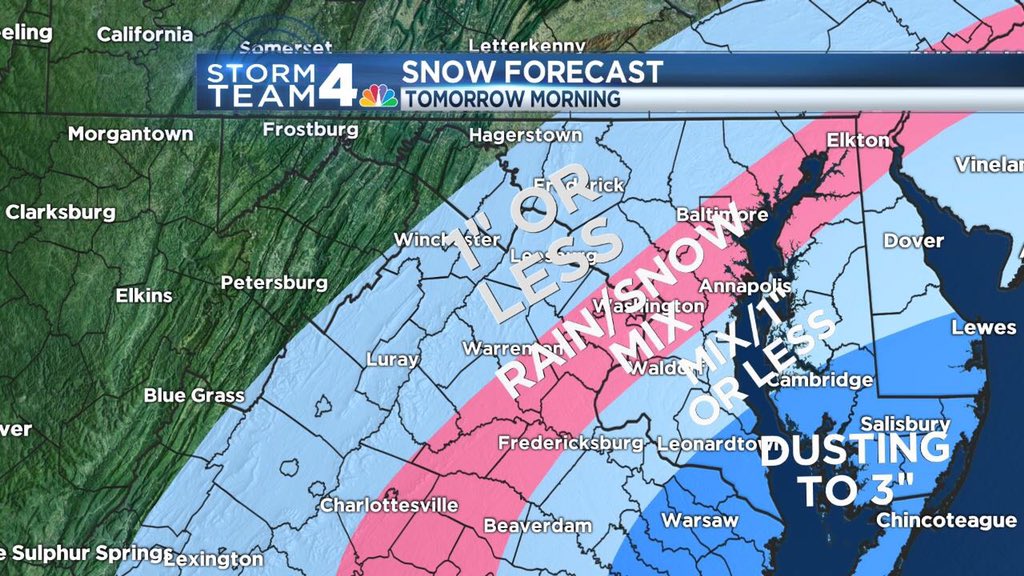
**A Winter Weather Advisory is in effect for locations near and east of Interstate 95 until 10 a.m. Wednesday. The National Weather Service says there is a chance of snow of 1 to 3 inches in the area. They are warning that roads may become snow covered and slippery.**
** Friday, Feb. 5 will be a StormTeam 4 Weather Alert day**
Rain showers in southern Maryland and the Northern Neck will slowly meander westward this evening into the overnight hours. As temps drop, snow will start to mix in after midnight. Rain and snow showers will impact the area as late as 9 a.m. tomorrow. Because of the timing, this could slow the morning rush and therefore it will be a Storm Team 4 Weather Alert. The National Weather Service has issued a winter weather advisory for St. Mary’s and Calvert Counties from midnight until 10 a.m. for the potential of 1 to 3 inches of snow.
One concern will be how far west this system will track. It could be a pretty tight cut-off with Frederick, Loudoun, and Prince William Counties (and areas west) remaining dry. There is even a slim chance the D.C. Metro area stay dry. Right now, though, it looks like rain and snow inside the Beltway is more likely than not with little to no accumulation for the majority of the area.
As this system pulls away tomorrow morning, winds will become breezy with temps feeling like they are only in the 30s throughout the day. The weekend is looking nice with a mix of clouds and sun and highs around 50. We have another coastal system we are watching for early next week that could bring us a rain/snow mix Monday into Tuesday. However, this is still a lot of uncertainty with this system so stay tuned for updates.
Tonight: Cloudy with Rain Showers in southern MD/Northern Neck spreading west overnight.
Snow mixing in spots after midnight.
Friday: Snow/Rain Showers in the morning especially Washington/east.
Dusting to 3” possible southern MD. Rain/Snow mix in DC Metro, Chance of Snow west with 1” or less possible. Clouds thin, cold and breezy.
Highs: Low to Mid 40s, feels like mid to upper 30s with the winds
Saturday: Partly Sunny
Highs: Mid 40s
Sunday: Mostly Sunny
Highs: Around 50
Welcome to Fairfax Underground, a project site designed to improve communication among residents of Fairfax County, VA. Feel free to post anything Northern Virginia residents would find interesting.
WEATHER ALERT: Snow tomorrow morning could impact rush hour
Posted by:
Fox News
()
Date: February 04, 2016 08:08PM
http://wtop.com/weather/
Lows: Low to Mid 30s
Updated Storm Team 4 forecast 6:22 p.m. Thursday, Feb. 4
**A Winter Weather Advisory is in effect for locations near and east of Interstate 95 until 10 a.m. Wednesday. The National Weather Service says there is a chance of snow of 1 to 3 inches in the area. They are warning that roads may become snow covered and slippery.**
** Friday, Feb. 5 will be a StormTeam 4 Weather Alert day**
Rain showers in southern Maryland and the Northern Neck will slowly meander westward this evening into the overnight hours. As temps drop, snow will start to mix in after midnight. Rain and snow showers will impact the area as late as 9 a.m. tomorrow. Because of the timing, this could slow the morning rush and therefore it will be a Storm Team 4 Weather Alert. The National Weather Service has issued a winter weather advisory for St. Mary’s and Calvert Counties from midnight until 10 a.m. for the potential of 1 to 3 inches of snow.
One concern will be how far west this system will track. It could be a pretty tight cut-off with Frederick, Loudoun, and Prince William Counties (and areas west) remaining dry. There is even a slim chance the D.C. Metro area stay dry. Right now, though, it looks like rain and snow inside the Beltway is more likely than not with little to no accumulation for the majority of the area.
As this system pulls away tomorrow morning, winds will become breezy with temps feeling like they are only in the 30s throughout the day. The weekend is looking nice with a mix of clouds and sun and highs around 50. We have another coastal system we are watching for early next week that could bring us a rain/snow mix Monday into Tuesday. However, this is still a lot of uncertainty with this system so stay tuned for updates.
Tonight: Cloudy with Rain Showers in southern MD/Northern Neck spreading west overnight.
Snow mixing in spots after midnight.
Friday: Snow/Rain Showers in the morning especially Washington/east.
Dusting to 3” possible southern MD. Rain/Snow mix in DC Metro, Chance of Snow west with 1” or less possible. Clouds thin, cold and breezy.
Highs: Low to Mid 40s, feels like mid to upper 30s with the winds
Saturday: Partly Sunny
Highs: Mid 40s
Sunday: Mostly Sunny
Highs: Around 50
Re: WEATHER ALERT: Snow tomorrow morning could impact rush hour
Posted by:
Keonte Shevontay
()
Date: February 04, 2016 08:15PM
Should fuck things up quite well since niggers, chinks, spics, and soccer moms can't seem to drive well when it's 70 degrees and clear as day. Probably should only give licenses out to males, and mostly white males between the ages of 25-60. The rest can just take the niggerfied metro.
Re: WEATHER ALERT: Snow tomorrow morning could impact rush hour
Posted by:
Douchebags...
()
Date: February 04, 2016 09:20PM
Typical hysteria from all sides. You can both go fuck your worthless sorry-ass selves for posterity.
Re: WEATHER ALERT: Snow tomorrow morning could impact rush hour
Posted by:
Ebony Ki'Eesha Jefferson
()
Date: February 05, 2016 02:26AM
I drive good in snow. I even do it puttin on my makeup, eaten my McDonalds, and adjusting my wig. I talk to baby daddy on blue toof.
Re: WEATHER ALERT: Snow tomorrow morning could impact rush hour
Posted by:
Cool story
()
Date: February 05, 2016 03:03AM
Douchebags... Wrote:
-------------------------------------------------------
> Typical hysteria from all sides. You can both go
> fuck your worthless sorry-ass selves for
> posterity.
You can off yourself too for posterity. Make the world a better place!
-------------------------------------------------------
> Typical hysteria from all sides. You can both go
> fuck your worthless sorry-ass selves for
> posterity.
You can off yourself too for posterity. Make the world a better place!
Re: WEATHER ALERT: Snow tomorrow morning could impact rush hour
Posted by:
22124
()
Date: February 05, 2016 06:53AM
Flakes!
Re: WEATHER ALERT: Snow tomorrow morning could impact rush hour
Posted by:
22033
()
Date: February 05, 2016 07:26AM
A few flakes.
Re: WEATHER ALERT: Snow tomorrow morning could impact rush hour
Posted by:
Douchebags...
()
Date: February 05, 2016 07:34AM
Nothing here but the hysteria and stupidity of a couple of acting-out, middle-school assholes. Likely delinquents from Mary Ellen Henderson.
Re: WEATHER ALERT: Snow tomorrow morning could impact rush hour
Posted by:
Tiger Eye
()
Date: February 08, 2016 12:33AM
I need to stock up on bread, mild, TP, and condoms. Last time I ran out of condoms and had to use balloons. My dick so big so balloons did not work so well. :(
Re: WEATHER ALERT: Snow tomorrow morning could impact rush hour
Posted by:
roll tide
()
Date: February 08, 2016 01:51PM
don't forget to go to walmart for your bread and milk you fuckin retards